Miers Valley
[1] The name is possibly after Edward J. Miers, a marine biologist from the British Museum (Natural History) who examined crustacea from the Erebus and Terror expeditions.
A prominent rock peak, 1,430 metres (4,690 ft) high, on the ridge that borders the east side of the head of Blue Glacier.
The New Zealand Blue Glacier Party of the Commonwealth Trans-Antarctic Expedition (CTAE; 1956–58) established a survey station on its summit in December 1957.
A bare rock peak over 800 metres (2,600 ft) high, culminating the ridge north of Miers Glacier and forming the south rampart of the valley named Shangri-la in Victoria Land.
Named in association with Shangri-la by the New Zealand Victoria University of Wellington Antarctic Expedition (VUWAE), 1960–61.
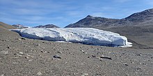
A small glacier north of Terminus Mountain in Victoria Land, occupying the upper (western) portion of Miers Valley.
Mountain over 800 metres (2,600 ft) high, standing immediately south of Adams Glacier on the east side of the Royal Society Range in Victoria Land.
A stream from the lake flows down the valley in the warmest weather to reach the coast of Victoria Land.
A small elevated plain 550 metres (1,800 ft) high between Findlay Ridge and Miers Valley.
[16] This article incorporates public domain material from websites or documents of the United States Geological Survey.