Miguel Hidalgo, Mexico City
Tacubaya and Tacuba both have long histories as independent settlements and were designated as “Barrios Mágicos” by the city for tourism purposes.
It is bordered by the boroughs of Azcapotzalco, Cuauhtémoc, Benito Juárez, Álvaro Obregón and Cuajimalpa, and the State of Mexico to the west.
[3] The borough consists of an area which used to the west bank of Lake Texcoco, with three major zones, Tacuba, Chapultepec and Tacubaya.
The geography of the borough includes canyons, hills and mesas associated with the Sierra de las Cruces, most present in the southwest bordering Cuajimalpa.
[4] One of the newest parks in the borough is located on Lago Caneguin in Colonia Argentina, created over a former roadway called Ruta 100.
[3] The borough is the second most visited by tourists in Mexico City according to the Secretary of Tourism of the Federal District, receiving just under 13% of total visitors in 2006.
Five star hotels include the Presidente Intercontinental, the Marriott and Niko, all located on Paseo de la Reforma next to Chapultepec Park.
Commercial centers include eighteen traditional markets, the upscale shopping corridor along Avenida Presidente Masarik in Polanco and various malls.
[3] Bases for unlicensed taxis and areas crowded with unregulated street vendors is a major problem, especially around Christmas time.
[3] The borough was created by fusing various former municipalities such as Tacuba, Tacubaya and the Chapultepec Park area along with the neighborhoods such as Polanco, Lomas de Chapultepec, Bosques de las Lomas, Popotla, Las Pensil, La Argentina, America, Santa Julia and Observatorio.
[12] Until the 20th century, Tacuba, Chapultepec and Tacubaya had separate histories, all part of the Federal District of Mexico City during most of this entity's existence under various arrangements.
The territory was reorganized into Mexico City proper and thirteen boroughs: Guadalupe-Hidalgo, Azcapotzalco, Iztacalco, General Anaya, Coyoacán, San Ángel, La Magdalena Contreras, Cuajimalpa, Tlalpan, Iztapalapa, Xochimilco, Milpa Alta and Tláhuac.
In 1970, the city area was subdivided into four parts, Cuauhtémoc, Venustiano Carranza, Benito Juárez and Miguel Hidalgo.
Tacuba, Chapultepec and Tacubaya in the pre Hispanic period were located on the western shore of Lake Texcoco, just west of the island where the Aztecs established Tenochtitlan.
Constant flooding problems, almost forced the Spanish to move the capital to Tacubaya in the early 17th century; however, it was decided to drain and fill in the lake instead.
During the first third of this century, the country estates, farmland and ranches between Tacuba, Tacubaya and Mexico City proper were turned into subdivisions for housing, with roads and other paved areas taking over empty fields.
[12] One reason for the westward expansion was that wealthy families were abandoning the historic center of Mexico City for newer areas.
[14][15][16] The area has been considered special since long in the pre Hispanic period when it was a ceremonial site and later a retreat for Aztec emperors.
[18] The museum has a number of antecedents beginning from the colonial period, but the current institution was created in the 1960s with the building and grounds designed by architect Pedro Ramírez Vázquez.
This museum has an area of 44,000m2 and 25 exhibit halls with sections devoted to each of the major pre-Hispanic civilizations in Mexico including the Aztec, Maya, Toltec and Olmec.
Residents included Maximiliano I of Mexico, who had Paseo de la Reforma, which passes through Chapultepec Park, built to connect the area with the center of the city.
When the Tenochtitlan and Texcoco decided to ally against Azcapotzalco, Tlacopan did not resist and for this reason is considered to be the third of the Aztec Triple Alliance.
The façade is mostly Baroque with the portal marked the two grooved Doric columns and topped by a frieze with vegetative design done in relief.
The interior is focused on the main altar, which is gilded and has twelve colonial era paintings of the Virgin Mary and various saints along with Salomonic columns.
Here are the remains of a Montezuma cypress, under which it is said that Hernán Cortés sat and wept after being run out of Tenochtitlan during La Noche Triste in 1520.
Next to the plaza where this tree is found, there is an old mansion whose east side has a mural called “Noche de la Victoria” (Night of the Victory) done in 2010.
Today it is the site of the Universidad del Ejército y Fuerza Aérea which still trains part of Mexico's military.
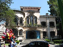
The area remained rural with orchards, important grain mills and abundant water from its three main rivers of Piedad, Morales and Xola, attracting the wealthy to build country homes here.
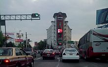
Edificio Ermita is one of the first skyscrapers in Mexico City, constructed in 1930 in Art Deco style by architect Juan Segura.
[25] Most of the diplomatic missions in Mexico City are located in Miguel Hidalgo, mainly in the Lomas de Chapultepec and Polanco area.