Military Grid Reference System
(In some cases, squares adjacent to a Grid Zone Junction (GZJ) are clipped, so polygon is a better descriptor of these areas.)
The 6° wide UTM zones, numbered 1–60, are intersected by latitude bands that are normally 8° high, lettered C–X (omitting I and O).
This same notation is used in both UTM and MGRS, i.e. the UTM grid reference system; the article on Universal Transverse Mercator shows many maps of these grid zones, including the irregularities for Svalbard and southwest Norway.
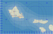
In the map (figure 1), which uses the AA scheme, we see that Honolulu is in grid zone 4Q, and square FJ.
The third part of an MGRS coordinate is the numerical location within a 100,000 meter square, given as n + n digits, where n is 1, 2, 3, 4, or 5.
The resolution in this case is 1 meter, so the MGRS coordinate would represent a 1-meter square, where the easting and northing are measured to its southwest corner.
However, truncation is used in GEOTRANS since version 3.0, and in NGA Military Map Reading 201[3] (page 5) and in the US Army Field Manual 3-25.26.
But an MGRS grid reference can denote an area that crosses a latitude band boundary.
In these cases, software that interprets an MGRS grid reference should accept both of the possible latitude band letters.
The lower the input precision, the more "slop" is allowed in the final check on the latitude zone letter.
This is to handle an issue raised by some F-16 pilots, who truncate MGRS strings that they receive from the Army.
The correction causes truncated strings to be considered valid if any part of the square which they denote lies within the latitude zone specified by the third letter of the string.In the polar regions, a different convention is used.