Military history of Myanmar
In the 18th and early 19th centuries, highly militaristic Konbaung kings had built the largest empire in mainland Southeast Asia until they encountered the British in present-day northeast India.
Since independence in 1948, the country's various political and ethnic factions have been locked in one of the longest civil wars today, with myriad insurgencies receiving implicit and explicit help from various external states.
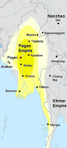
The kingdom went into decline in the 13th century as the continuous growth of tax-free religious wealth—by the 1280s, two-thirds of Upper Burma's cultivable land had been alienated to the religion—affected the crown's ability to retain the loyalty of courtiers and military servicemen.
In the south, Wareru, the man who had seized the governorship of Martaban in 1285, consolidated Mon-speaking regions of Lower Burma, and declared Ramannadesa (Land of the Mon) independent in 1287.
In January 1300, the Myinsaing forces led by Athinhkaya seized the southernmost Mongol garrisons named Nga Singu and Male, just north of modern Mandalay.
)[28][29] Faced with more pressing rebellions elsewhere, the Ming government gave up trying to impose imperial order in the Yunnan borderlands, and had to be content with receiving nominal tribute.
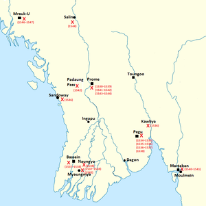
Nonetheless, the kingdom remained fragmented into three power centres: the Irrawaddy delta in the west, Pegu in the middle and Martaban in the southeast, each with its own chief, who pledged nominal allegiance to the high king.
Of these, the remote vassal state of Toungoo (Taungoo), tucked away in the southeastern corner across the Pegu Yoma range, proved most troublesome to successive kings at Ava.
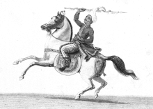
Next year, near the end of the rainy season on 14 October 1548, (13th waxing of Tazaungmon 910 ME), 12,000 strong Toungoo forces led by Tabinshwehti and Bayinnaung invaded Siam via the Three Pagodas Pass.
[59][60] On 12 March 1552, Bayinnaung defeated Pegu's ruler Smim Htaw in single combat on elephants, and the victor's forces brutally sacked the city.
A three-pronged invasion (10,000 men, 300 horses, 30 elephants) led by Gen. Binnya Dala faced minimal resistance, and achieved formal surrender c. February 1560.
Knowing that Siam be much more difficult than Shan states and Lan Na campaigns, Bayinnaung assembled the largest army yet—60,000 men, 2400 horses and 360 elephants,[70] two and a half times larger than his previous high.
[80] On 9 September 1580, Bayinnaung sent a large land and naval invasion force to bring Arakan, which was not yet part of his realm, the largest empire in the history of Southeast Asia.
The Mughal viceroy of Bengal first lured the Portuguese mercenaries in the service of King Sanda Thudhamma guarding the Chittagong region to defect by giving them fiefs.
One of Bayinnaung's sons, Nyaungyan, immediately began the reunification effort, successfully restoring central authority over Upper Burma and Shan States by 1606.
He captured Nyaungshwe in February 1601, and the large strategic Shan state of Mone in July 1603, bringing his realm to the border of Siamese Lan Na.
Reinforced Burmese armies led by the king's brothers Thalun and Minye Kyawswa II invaded the Chinese Shan states in present-day southern Yunnan in May 1622.
[114] While Burma had its hands full with the Ming Chinese invasions, Siam's King Narai attempted to pick off the upper Tenasserim coast and Lan Na.
Alaungpaya, the founder of the Konbaung dynasty, quickly emerged as the main resistance leader, and by taking advantage of Hanthawaddy's low troop levels, went on to conquer all of Upper Burma by the end of 1753.
The English East India Company had seized Negrais (Haigyi Island) at the southwestern tip of the Irrawaddy delta since April 1753 because they were concerned about the French influence over Pegu, and wanted their own foothold in Lower Burma.
The Siamese who originally were concerned about the rising power of Restored Hanthawaddy now actively supported the ethnic Mon rebels operating in the upper Tenasserim coast.
From their northernmost forts in Hukawng Valley in present-day northern Kachin State, the Burmese army crossed the 9,000-foot high Himalayan Patkai range, and finally entered Assam in early 1817.
Per the Treaty of Yandabo, Burma was forced to cede Arakan, Manipur, Assam and Tenasserim and pay a large indemnity of one million pounds sterling.
After the end of the rainy season, in November, the British captured Prome, and pushed up to Myede on the Irrawaddy, and took Toungoo on the Sittaung, facing minimal Burmese resistance.
On 20 December 1852, the British issued a proclamation of annexation, taking Lower Burma, up to the latitude running directly east–west across the country to the borders of Karenni states, 6 miles (9.65 km) north of Myede (and Toungoo).
Because he was still concerned about the British threat, Mindon could only send several thousand infantry troops from the Mone (Mong Nai) garrison to relieve the Siamese siege of Kengtung.
[176] At the beginning of World War I, the only indigenous military regiment in the British Indian Army, the 70th Burma Rifles, consisted of three battalions, made up of Karens, Kachins and Chins.
Driven out by the Chinese Communist forces, Nationalist KMT troops (about 16,000 at the peak) planned to use the region east of the Salween river as a base from which to regain their homeland.
[4] Prior to the ceasefires, the largely Burman-dominated armed forces made futile annual dry season campaigns, only to see the rebels return after they left.
The Burman dominated central governments (civilian or military-alike) have not been able to reach a political agreement even though the stated goal of most, if not all, major ethnic insurgencies (including the KNU) is autonomy, not secession.