Mill Basin, Brooklyn
It is on a peninsula abutting Jamaica Bay and is bordered by Avenue U on the northwest and the Mill Basin/Mill Island Inlet on its remaining sides.
Mill Basin is adjacent to the neighborhood of Bergen Beach to the northeast, Flatlands to the northwest, Marine Park to the southwest, and Floyd Bennett Field and the former Barren Island to the southeast.
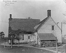
The archipelago was then occupied by the Schenck and Crooke families through the late 19th century, and remained a mostly rural area with oyster fishing.
In an effort to develop Mill Basin as a seaport district, ports and dry docks were built in the early 20th century, though a lack of railroad connections hindered the area's further growth.
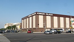
Mill Basin is primarily residential, with a mix of commercial and industrial uses, including the Kings Plaza shopping mall in its western part.
The area around Mill Basin consists of a mostly white population as of the 2010 United States Census, and is sparsely served by public transportation.
It was later connected to the uplands of nearby Bergen Beach, creating the continuous embankment between Mill and Paerdegat basins later used for the construction of the Belt Parkway.
Small commercial overlays and recreational waterfront uses also exist, and the area between Avenue U and the Mill Basin waterway is zoned for heavy industry.
[10] According to a map The New York Times published in 2009, Old Mill Basin can be considered to reach as far north as Avenue N.[8] The local Lenape Native Americans originally inhabited the area.
They referred to the surrounding area, including Mill and Barren Islands, as "Equendito" or "Equindito", a name that probably means "Broken Lands".
[5]: 4 In 1636, as Dutch settlers expanded outward from present-day Manhattan, they founded the town of Achtervelt (later Amersfoort, then Flatlands) and purchased 15,000 acres (6,100 ha) around Jamaica Bay.
[15]: 21 The Flatbush Improvement Company brought marshland and engaged the firm of Atlantic, Gulf and Pacific to dredge creeks and fill in meadows.
[6]: 68 As compensation, Atlantic, Gulf and Pacific acquired ownership of the eastern portion of Mill Island,[5]: 37 which comprised about 800 acres (320 ha) of land.
Atlantic, Gulf and Pacific built factories and worker housing on its half of the island, and in 1916, began laying sidewalks and utilities.
[18] In 1917 the New York City Department of Docks awarded a contract to dredge the Mill Basin channel, along the southern and western sides of the island, to the federal government.
[20] In 1925, the Flatbush Avenue extension to Rockaway Inlet opened,[27] providing an additional 2,700 feet (820 m) of dock facilities and a strip of land for a road across the marshes.
[24] The Port Authority of New York and New Jersey offered to build the new railroad link for $2 million and lease it to the city,[29] but Mill Basin's further development was hindered when plans for rail service to the rest of Brooklyn went unrealized.
[31] Originally, real-estate developers suggested that 300 acres (120 ha) in Mill Basin could be used for the new airport, which would allow the airfield to open before the end of 1928.
[32] Ultimately, New York City's aeronautical engineer Clarence Chamberlin selected nearby Barren Island as the site for the new airport, which later became Floyd Bennett Field.
[7] The 1939 WPA Guide to New York City mentions that the area comprising present-day Mill Basin and Bergen Beach was the residence of "pathetic communities of squatters, who live in makeshift houses, and eke out a living by fishing and scouring the near-by city dumps for odd necessities".
[38] Residential development on the peninsula began after World War II, when Atlantic, Gulf and Pacific sold a large plot of land to the firm of Flatbush Park Homes.
[8] Over a hundred brick bungalows were built in the late 1940s and early 1950s, many of which were later replaced by big, custom-built, detached one-family houses on lots measuring 50 by 100 feet (15 by 30 m).
[7] Starting in the 1950s, a series of suburban waterfront communities were rapidly developed in Southeast Brooklyn, including present-day Bergen Beach and Canarsie as well as Mill Basin.
[49] Another controversy in 1966 surrounded a "boatel", or motel with boating docks, that had been planned for the site of a marsh south of the Mill Basin waterway.
[50] The boatel site, at the intersection of Belt Parkway and Flatbush Avenue, was supposed to contain a shopping mall with docks for up to 300 boats.
[10] Mill Basin is part of Brooklyn Community Board 18, which also includes Canarsie, Bergen Beach, Georgetown, Marine Park, and the southern portion of Flatlands.
[59] Mill Basin is in ZIP Code 11234, which also includes Georgetown, Marine Park, Bergen Beach, and the southern portion of Flatlands.
It is named after Monsignor Thomas J. Crawford, the first pastor of the Mary Queen of Heaven Church, four blocks north of the ballfields.
[64] Named after aviator Floyd Bennett, the field was formerly the city's first municipal airport, and is now part of the Gateway National Recreation Area.
[79] The Mill Basin Bridge is a vital component of the Belt Parkway and Jamaica Bay Greenway connecting the southern coastlines of Brooklyn and Queens.