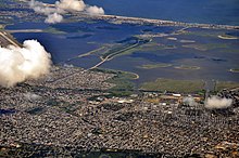
Jamaica Bay
Politically, it is primarily divided between the boroughs of Brooklyn and Queens in New York City, with a small part touching Nassau County.
[3][4]) The location of Jamaica Bay, combined with its rich food resources, make it an important habitat for both plants and animals.
[5] This geographic location also provides valuable feeding habitat to marine and estuarine species migrating between the New York Bight and the Hudson River and Raritan River estuaries, and to a diverse community of migratory birds and insects that use the Bay for refueling during transit between summer breeding and overwintering grounds.
[5] Jamaica Bay is a saline to brackish, eutrophic (nutrient-rich) estuary covering about 25,000 acres (100 km2), with a mean depth of 13 feet (4.0 m), a semidiurnal tidal range averaging 4.9 ft (1.5 m), and a residence time of about three weeks.
Measurements taken during recent surveys in Jamaica Bay indicate average yearly ranges for temperature of 34 to 79 °F (1 to 26 °C), salinity of 20.5 to 26 parts per thousand, dissolved oxygen of 3.5 to 18.5 milligrams/liter, and pH of 6.8 to 9.
[7] The center of the bay is dominated by subtidal open water and extensive low-lying islands with areas of salt marsh, intertidal flats, and uplands important for colonial nesting waterbirds.
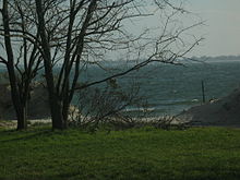
The extensive intertidal areas are rich in food resources, including a variety of benthic invertebrates and macroalgae dominated by sea lettuce (Ulva latuca).
In addition, two freshwater impoundments were created on Rulers Bar Hassock in the Jamaica Bay Wildlife Refuge; the smaller 49 acres (0.20 km2) freshwater West Pond is kept as open water, and the larger 120 acres (0.49 km2) slightly brackish East Pond is controlled to expose mudflats.
Some of the islands in the bay have upland communities, including grasslands consisting of little bluestem (Schizachyrium scoparium), switchgrass (Panicum virgatum), and seaside goldenrod (Solidago sempervirens); scrub-shrub containing bayberry (Myrica pensylvanica), beach plum (Prunus maritima), sumac (Rhus spp.
), and poison ivy (Toxicodendron radicans); developing woodland consisting of hackberry (Celtis occidentalis), willow (Salix spp.
Some engineers believed that shifting sand dunes and the tides in Jamaica Bay might make it impossible to construct the seaport district.
Dredging Paerdegat Basin was a key part of the plan, as it would allow easier access for ships headed to Canarsie.
[23] In January 1931, the New York City Board of Estimate approved a plan to build railroads on both sides of Paerdegat Basin, connecting the LIRR to Canarsie Pier to the east and to Floyd Bennett Field to the west.
[31][32] On November 12, 2001, American Airlines Flight 587, an Airbus A300, crashed after takeoff from JFK Airport after its vertical stabilizer separated in-flight and landed in Jamaica Bay.
Though much improved, pollution is still a problem, and after once enjoying a worldwide reputation for oysters and supporting a vigorous fishing industry the area has been closed to shellfishing since the early 20th century.
To test this, in the hope of preventing further losses, the National Park Service plans to dredge a small area of the bay in order to build up the soil in about 1 acre (4,000 m2) of marsh.
[37] In an effort to reduce the amount of nitrogen being discharged into Jamaica Bay, the New York City Department of Environmental Protection announced the installation of enhanced treatment measures.
An innovative technology, called the Ammonia Recovery Process, is now being designed by ThermoEnergy Corporation, which will further reduce nitrogen discharges from the bay by 3,000 pounds per day by 2014.
[40][41] Small areas in the upland buffer around the bay and on the Rockaway Peninsula remain in private residential or commercial ownership.
Jamaica Bay and Breezy Point have been designated as Significant Coastal Fish and Wildlife Habitats by the New York State Department of State, and the bay up to the high tide line was designated as a Critical Environmental Area by the New York Department of Environmental Conservation.
In 2012, the City of New York and the National Park Service signed an agreement to jointly manage Jamaica Bay and restore its parkland and greenspaces.
[42] Hurricane Sandy hit the city in force in October 2012, causing billions of dollars of damage, and inundating coastal regions, including Jamaica Bay, with a storm surge estimated at close to 2.5 meters.
Later that year, Mayor Bloomberg, together with the then Secretary of the Interior Sally Jewell, announced the establishment of the Jamaica Bay Science and Resilience Institute, a multidisciplinary consortium of academic, governmental and community partners coordinated by the City University of New York.

1. Hudson River , 2. East River , 3. Long Island Sound , 4. Newark Bay , 5. Upper New York Bay , 6. Lower New York Bay , 7. Jamaica Bay , 8. Atlantic Ocean