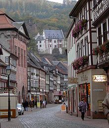
Miltenberg
Since about the beginning of the 20th century, after buying land from the neighbouring community of Großheubach, Miltenberg has been expanding on the right bank.
In pre-Roman times, circular ramparts were built on the Greinberg above Miltenberg and on the Bürgstadter Berg (also known as Wannenberg) northeast of Bürgstadt.
[4]: 97 In the 150s, the Roman Empire pushed outwards its fortified border in Germania, establishing the Upper Germanic-Rhaetian Limes which replaced the Odenwald-Neckar-Limes.
The former, which was likely built some years in advance of the overall change in the borderline, housed a cohort, the southernmost military presence on the Main.
In addition, a scout unit (exploratores Triputienses) was based in the area, either in the Altstadtkastell or in a nearby separate fort.
The cohort castrum likely was continuously occupied until about 260, when the Romans abandoned this part of their border after heavy raids by Germanic tribes.
[5][4]: 75–81, 85 The Limes itself met the Main near the eastern castrum, Miltenberg-Ost which housed a Numerus, a smaller military unit.
Burgundians and Alemanni moved through the lower Main region, but it was only under the Franks (after 500 AD) that the population density again rose noticeably.
[4]: 68 At this point, the population of Walehausen/Wallhausen was likely moved to the village Miltinburc, previously founded by Mainz during the first quarter of the 13th century and mentioned first in 1226.
[4]: 69 Already by the early Middle Ages, the area's red buntsandstein was highly sought-after, with products such as grindstones and columns being hewn in the surrounding woods.
Miltenberg/Miltinburc grew around a Mainz toll station built on the river bank in the 13th century, protected by the Mildenburg (castle).
It profited from the Stapelrecht which forced passing merchants to store their wares locally and offer them for sale for some days.
[4]: 85 During its financial heyday, Miltenberg also saw considerable construction activity: of the many secular and non-Christian Gothic structures today only the winery, a warehouse and the former synagogue remain.
Gothic churches included the Stadtkirche (St Jakobus) but it mostly lost its original exterior character when it was rebuilt in the 1830s.
[4]: 86 Its strategic position on the bend of the navigable river and on the important trade route Nuremberg-Frankfurt made Miltenberg a politically influential member of the nine town league (Neun-Städte-Bund) of Mainz.
After securalization and the Reichsdeputationshauptschluss, Miltenberg passed to the Principality of Leiningen, with which it was incorporated into the Grand Duchy of Baden in 1806.