Mimbres River
The Mimbres forms from snowpack and runoff on the southwestern slopes of the Aldo Leopold Wilderness in the Black Range at 33°06′58″N 107°51′04″W / 33.11611°N 107.85111°W / 33.11611; -107.85111 in Grant County.
The uplands watershed are administered by the United States Forest Service, while the land in the Mimbres Valley is mostly privately owned.
[3][4] The Mimbres River Basin has an area of about 13,000 km² (5,140 mi²) and extends slightly into northern Chihuahua, Mexico.
This agriculture increasingly depended upon irrigation from the perennial and storm flow of the Mimbres River.
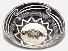
In the later part of the pithouse period, distinctive Mimbres pottery black-on-white designs grew more complex and ornate.