List of Mississippi River floods
After the flood, Congress in 1849 passed the Swamp Act providing land grants to build stronger levees.
The State of Iowa experienced significant flooding extending to the Lower Mississippi River basin.
Historical evidence suggest flooding occurred in the eastern Plains, from Nebraska to the Red River basin, but these areas were sparsely settled by white settlers in 1851.
According to the New Orleans Daily Picayune of May 3, thirty-one of Louisiana's fifty-three parishes (home to some 375,000 people) were entirely or partially underwater.
The effects were much more devastating in the Lower Mississippi Valley, with an estimated 20,000 people made homeless in Arkansas alone.
Such was the devastation that, in its wake, Southern Democrats and Midwestern Republicans in Congress hailing from those states afflicted by the flooding made common cause to increase appropriations for the Rivers and Harbor Act to $19 million, $5.4 million of which was earmarked for internal improvements and federal aid to the flooded areas.
While not opposed to internal improvements on principle, President Chester A. Arthur nonetheless vetoed the Act on August 1, 1882.
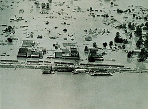
The flooding was catastrophic, causing losses to most planted crops in the region and disrupting freight and passenger rail service on the West Bank of the river for several months.
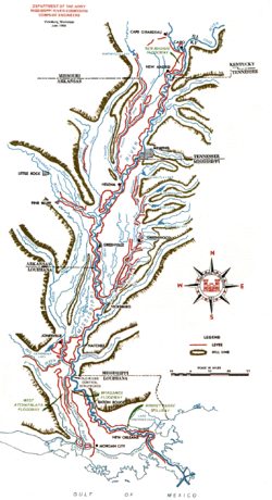
The White and Little Red rivers broke through the levees in Arkansas in February, flooding over 400 km2 (99,000 acres) with 3 to 5 m (9.8 to 16.4 ft) of water.
[12] The first levee break along the Mississippi River occurred a few miles south of Elaine, Arkansas, on March 29.
[5] Flooding between March and May resulted in Baton Rouge reaching its second highest recorded crest at 45.18 feet (13.77 m) on April 29.
[14] The crests of that April exceeded previous records by several feet at many river gauge sites.
Red River Landing, Louisiana, reached the 4th highest crest of record at 60.52 feet (18.45 m) on June 5 and was flooded for 115 days.
[5][17] Between April 11 and May 12, heavy rain in the Mississippi River Valley necessitated the opening of the Bonnet Carre Spillway for the first time in 11 years.
Rising from springtime snowmelt, the river and many of its tributaries began to swell to record levels by the beginning of May.
U.S. President Barack Obama declared the western counties of Kentucky, Tennessee, and Mississippi federal disaster areas.
For the second time in 38 years, the Morganza Spillway has been opened, deliberately flooding 4,600 square miles (12,000 km2) of rural Louisiana to save most of Baton Rouge and New Orleans.
[19] The Upper Mississippi River flooded in the summer of 2014 as the result of record rainfall in Minnesota, Iowa, Wisconsin and Illinois.
