Models of migration to the Philippines
Events/Artifacts (north to south) Events/Artifacts Artifacts Since H. Otley Beyer first proposed his wave migration theory, numerous scholars have approached the question of how, when and why humans first came to the Philippines.
[1][3][4][5] The various "Out of Sundaland" hypotheses, posited by a minority of modern authors and differing slightly in the details, is similar to F. Landa Jocano's "Core Population" hypothesis.
However, instead of the Philippines, they assume the origin of the Austronesian peoples as being the now sunken Sundaland landmass (modern Sumatra, Java, Borneo, and the Malay Peninsula).
These models have been criticized as relying only on mtDNA genetic data without accounting for admixture events, thus having results that mistakenly combine the much older Paleolithic Negrito populations with the newer Neolithic Austronesian peoples.
According to Solheim, "The one thing I feel confident in saying is that all native Southeast Asians are closely related culturally, genetically and to a lesser degree linguistically.
On the basis of a careful analysis of artifacts, he suggests the existence of a trade and communication network that first spread in the Asia-Pacific region during its Neolithic age (c.8,000 to 500 BC).
According to Solheim's NMTCN theory, this trade network, consisting of both Austronesian and non-Austronesian seafaring peoples, was responsible for the spread of cultural patterns throughout the Asia-Pacific region, not the simple migration proposed by the Out-of-Taiwan hypothesis.
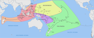
In about 4000 to 3000 BC, these peoples continued spreading east through Northern Luzon to Micronesia to form the Early Eastern Lobe, carrying the Malayo-Polynesian languages with them.
The integration of Southeast Asia into Indian Ocean trading networks around 2,000 years ago also shows some impact, with South Asian genetic signals present within some Sama-Bajau communities.
Heading that department for 40 years, Professor Beyer became the unquestioned expert on Philippine prehistory, exerting early leadership in the field and influencing the first generation of Filipino historians and anthropologists, archaeologists, paleontologists, geologists, and students the world over.
[21] His claims that the Malays were the original settlers of the lowland regions and the dominant cultural transmitter now seem untenable, no subsequent evidence has emerged to support his "Dawn Man",[21] and improved bathymetric soundings have established that there was almost certainly not a land bridge to Sundaland,[22] although most of the islands were connected and could be accessed across the Mindoro Strait and Sibutu Passage.
Writing in 1994, Philippine historian William Scott concluded that "it is probably safe to say that no anthropologist accepts the Beyer Wave Migration Theory today.
[25] Scott also asserts that the Sulu Archipelago is not the peak of a submerged mountain range connecting Mindanao and Borneo, but the exposed edge of three small ridges produced by tectonic tilting of the sea bottom in recent geologic times.
According to Scott, it is clear that Palawan and the Calamianes do not stand on a submerged land bridge, but were once a hornlike protuberance on the shoulder of a continent whose southern shoreline used to be the present islands of Java and Borneo.
Instead it suggests early inhabitants of Southeast Asia were of the same ethnic group with similar culture, but through a gradual process over time driven by environmental factors, differentiated themselves from one another.
While Palawan was connected directly to Sundaland during the last ice age (and separated from the rest of the Philippines by the Mindoro Strait), Callao Man's still-older remains (c. 67,000 B.P.)
The claimed evidence for this is fossil material found in different parts of the region and the movements of other people from the Asian mainland during historic times.
[27] Other prominent anthropologists like Robert Bradford Fox, Alfredo E. Evangelista, Jesus Peralta, Zeus A. Salazar, and Ponciano L. Bennagen agreed with Jocano.