Monadhliath Mountains
[2] The landscape of the Monadh Liath is one of the most ancient in Britain, its essentials as a secondary massif flanking the Cairngorms having evolved continuously since the Caledonian Mountains were created over 400 million years ago.
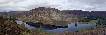
[3] Although icesheets have repeatedly covered the Monadh Liath, they have done little to change its character: there are no corries away from the Munros fringe, and only a few short glaciated troughs, notably Glen Killin on the north.
It has just become recognised that thin ice on the plateau is frozen to the ground, but as it starts to flow into the troughs it thickens, accelerates, and warms up so it can erode and enlarge them.
The actual reservoir and dam are not unduly intrusive, but the extensive network of heavy-duty access roads to service all the weirs diverting water into the catchment have altered its remoteness and wildness.
These roads have also facilitated a very large wind energy project, one of several encouraged by proximity to the high-capacity Beauly-Denny power transmission line over Corrieyairack Pass, and which now dominate the NW Grampian skyline in views from the Cairngorms and Western Highlands up to 50 miles (80 kilometres) away.