Monsoon trough
Depressions and tropical cyclones often form in the vicinity of the monsoon trough, with each capable of producing a year's worth of rainfall in a matter of days.
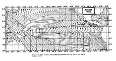
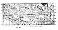
Monsoon troughing in the western Pacific reaches its zenith in latitude during the late summer when the wintertime surface ridge in the opposite hemisphere is the strongest.
Its poleward progression is accelerated by the onset of the summer monsoon which is characterized by the development of lower air pressure over the warmest part of the various continents.
North-south-oriented mountain barriers, like the Rockies and the Andes, and large massifs, such as the Plateau of Tibet, also influence atmospheric flow.
[11] If a circulation forms within the monsoon trough, it is able to compete with the neighboring thermal low over the continent, and a wind surge will occur at its periphery.
[14] In India, for example, 6 to 7 monsoon depressions move across the country yearly,[5] and their numbers within the Bay of Bengal increase during July and August of El Niño events.
Its abrupt movement to the north between May and June is coincident with the beginning of the monsoon regime and rainy seasons across South and East Asia.
This convergence zone has been linked to prolonged heavy rain events in the Yangtze river as well as northern China.