Mont-Cenis Lake
Due to its location, the natural outlet of the lake is the Cenise (Cenischia in Italian), which itself flows into the Doire Ripaire, a tributary of the Po River.
[3] The 1947 demarcation was made for two reasons: firstly, as part of Italy's war reparations to France, annexing this valley protected the region from potential new military invasions;[4] and secondly, to return these territories to the Savoyard communes of the Lanslebourg-Mont-Cenis canton in Haute Maurienne.
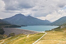
The choice of the reservoir site, at the center of the system, was made in the 1960s on the Mont-Cenis plateau, which had been integrated into French territory since the peace treaty with Italy in 1947.
The catchment area was enlarged through a network of conduits that artificially divert waters from the upper Arc and its left bank tributaries, Avérole and Ribbon, into the basin.
Though this lake had a lesser impact on the local economy compared to its counterpart in Roselend, primarily being a summer grazing area, it definitively altered the landscape of the pass and the way of life for residents in the heart of Haute Maurienne.
EDF acknowledged the loss of the priory by erecting a chapel in its place, consecrated on July 21, 1968, by André Bontems, Archbishop of Chambéry and Bishop of Maurienne and Tarentaise.
This advanced degradation triggered awareness, and through joint efforts of the Vanoise National Park and surrounding municipalities, a biotope protection zone accompanied by extensive restoration and redevelopment of the alpine garden was established.