Mount Cayley
[7][8][9] Deep seismic profiling 12.5 to 13 km (7.8 to 8.1 mi) below the volcano has identified a large bright spot, a reflector interpreted to be a mid-crustal magma chamber or body of very hot rock.
[5] The lack of evidence for volcano-ice interactions at Mount Cayley implies that all eruptive stages most likely took place prior to glacial periods.
[5][12] This involved the separation of the Explorer and Juan de Fuca plates off the British Columbia Coast, which had some significant ramifications for regional geologic evolution.
[12] The early Mount Cayley stage was characterized by the eruption of felsic lava flows and pyroclastic rocks onto a crystalline basement.
[7] Subsequent activity deposited a series of massive dacite flows up to 150 m (490 ft) thick, which form the summit and northern slope of Wizard Peak.
[7] The next eruptive period, the Vulcan's Thumb stage, built an edifice that grew upon the southwestern slope of the ancestral Mount Cayley stratovolcano.
This began with the eruption of massive dacite flows and blocky agglutinated breccias onto basement and older volcanic rocks of the Mount Cayley stage.
[7] It was the source of a 5 km (3.1 mi) long dacite flow that extends down the Shovelnose and Turbid creek valleys to near the Squamish River.
[6][7] The east lava dome was built upon blocky bedded tephra overlying basement rocks and consists of a steep-sided columnar jointed mass of dacite.
Extensive tufa and sinter deposits inhabit the main hot springs while bright red ferruginous ochre precipitates from several cold seeps in the vicinity.
[7] Because Mount Cayley is rich in coarse proximal pyroclastic deposits, some of them hydrothermally altered, it is especially prone to slope failure and debris avalanches.
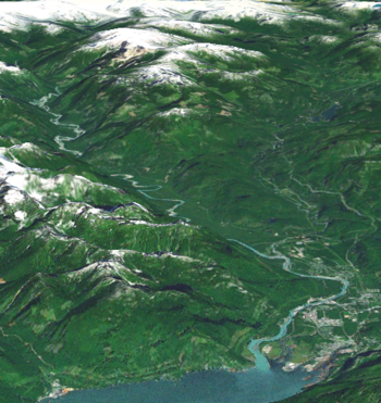
[6] At least three major debris avalanches have occurred from the western slope in the last 10,000 years, all of which blocked the Squamish River and formed temporary lakes upstream.
A 5,000,000 m3 (180,000,000 cu ft) landslide occurred in 1963 with the failure of a large volcanic block consisting of poorly consolidated tuff breccia and columnar-jointed dacite.
The debris flow reached the mouth of Turbid Creek where it destroyed a logging road bridge and blocked the Squamish River, introducing massive quantities of sediment.
[8] The third event took place along Turbid Creek in June 2014 and involved a debris flow that removed part of the Squamish River Forest Service Road.
Both the Mount Cayley volcano and The Black Tusk on the opposite side of the Cheakamus River valley are called taḵ'taḵmu'yin tl'a in7in'axa7en by the Squamish people.
[16] There had been no first ascent of the massif until July 1928 when an Alpine Club of Canada party, consisting of mountaineers R. E. Knight, W. G. Wheatley, E. C. Brooks, T. Fyles and B. Clegg, climbed Mount Cayley.
The name became official on April 2, 1929, and photographs of the peak were published with Fyles' description of first ascent in the 1931 Canadian Alpine Journal Vol XX.
[18] Geothermal exploration by Energy, Mines and Resources Canada commenced in 1977 with the drilling of two shallow boreholes on the west side of the volcano for temperature observation.
[18] Further drilling on the east and west sides of the volcano in 1980–1982 by Nevin Sadlier-Brown Goodbrand Limited on behalf of the GSC showed geothermal gradients ranging from 45 to 95 millikelvin per metre.
[7] GSC seismic data suggest that the volcano still contains magma, indicating possible future eruptive activity and associated volcanic hazards such as landslides.
The abundance of seismic activity and the sensitivity of the existing Canadian National Seismograph Network in this area would alert the GSC and possibly trigger an expanded monitoring effort.
Minor and possibly large landslides could occur and might temporarily block the Squamish River, as has happened in the past without earthquake shaking and intrusion-related deformation.
Air traffic would be diverted from the area and all airports covered by the plume would be closed, notably those in Vancouver, Victoria, Kamloops, Prince George and Seattle.
These would rapidly melt snow and ice in the summit area, generating debris flows that could reach Squamish and Daisy Lake, damaging much infrastructure.
The eruption plume would then spread to envelop most of the west coast from Seattle to Anchorage, causing all enclosed airports to be closed and all relevant flights to be diverted or cancelled.
As the lava dome spreads, it would periodically undergo gravitational collapse to generate dense pyroclastic flows into the Squamish and Cheakamus valleys.