Mount Cayley volcanic field
As a result, volcanic features in the MCVF that interacted with glacial ice lack rocks that display evidence of abundant water during eruption, such as hyaloclastite and pillow lava.
[5] The reason is that the mouth of the Columbia River empties directly into the subduction zone and deposits silt at the bottom of the Pacific Ocean, burying this large depression.
[7] However, earthquakes along the Cascadia subduction zone are less common than expected and there is evidence of a decline in volcanic activity over the last few million years.
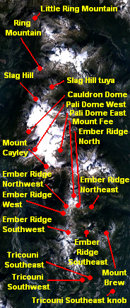
Lying on the western portion of Slag Hill is a lava flow that likely erupted less than 10,000 years ago due to the lack of features indicating volcano-ice interactions.
These volcanic rocks were extruded about 10,000 years ago during the waning stages of the Fraser Glaciation from a vent adjacent to upper Cauldron Dome that is currently buried under glacial ice.
With a summit elevation of 2,192 m (7,192 ft), Ring Mountain had its last volcanic activity between 25,000 and 10,000 years ago when the Fraser Glaciation was close to its maximum.
With a summit elevation of 2,147 m (7,044 ft), Little Ring Mountain had its last volcanic activity between 25,000 and 10,000 years ago when the Fraser Glaciation was close to its maximum.
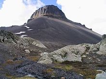
[18] Mount Brew, 18 km (11 mi) southwest of the resort town of Whistler, is a 1,757 m (5,764 ft) high lava dome composed of andesite or dacite that probably formed subglacially between 25,000 and 10,000 years ago.
After prolonged erosion destroyed much of the original stratovolcano, the third and final eruptive phase 0.3 to 0.2 million years ago produced a thick sequence of dacite lava flows.
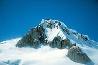
[21][22] None of the rocks comprising Mount Cayley show signs of interaction with glacial ice, which contracts with several of the smaller adjacent volcanoes.
Its volcanic rocks remain undated, but its large degree of dissection, coupled with evidence of glacial ice having overridden the volcano, indicates that it formed more than 75,000 years ago before the Wisconsinan Glaciation.
Pail Dome East on the eastern end of the Powder Mountain Icefield consists of andesite lava flows and small amounts of pyroclastic material.
However, the flows show evidence of interaction with glacial ice in their lower units, indicating that they were erupted about 10,000 years ago during the waning stages of the Fraser Glaciation.
[24] Pali Dome West consists of at least three andesite lava flows and small amounts of pyroclastic material; its vent is presently buried under glacial ice.
However, the flow shows evidence of interaction with glacial ice at lower elevations, implying that it was erupted during the waning stages of the Fraser Glaciation.
One of these sequences, known as Tricouni Southwest, creates a cliff on the eastern side of a north–south trending channel with a depth of 200 m (660 ft) adjacent to the High Falls Creek mouth.
Several fine-scale columnar joints and the overall structure of the lava flow suggest that its western portion, along the length of the channel, ponded against glacial ice.
In 1958, Canadian volcanologist Bill Mathews suggested that the lava flows were erupted during periods of subglacial activity and traveled through trenches or tunnels melted in glacial ice of the Fraser Glaciation.
[3] Slag Hill andesite consists of up to 70% dark brown volcanic glass, with the plagioclase matrix displaying varied degrees of trachytic texture.
[29] Recent seismic imaging from Natural Resources Canada employees supported lithoprobe studies in the region of Mount Cayley that created a large reflector interpreted to be a pool of molten rock roughly 15 km (9.3 mi) below the surface.
As the regional surface water percolates downward through rocks below the MCVF, it reaches areas of high temperatures surrounding an active or recently solidified magma reservoir.
These features are sometimes referred to as dying volcanoes because they seem to represent the last stage of volcanic activity as the magma at depth cools and hardens.
[36] Cultural ceremonial use, hunting, trapping and plant gathering occur around the Mount Garibaldi area, but the most important resource was a lithic material called obsidian.
Another possible explanation is subglacial eruptions created large amounts of glacial meltwater that scoured the surface of the exposed lava flows.
The Canadian National Seismograph Network has been established to monitor earthquakes throughout Canada, but it is too far away to provide an accurate indication of activity under the MCVF.
[31] A large volcanic eruption from any volcanoes in the MCVF would have major effects on the Sea-to-Sky Highway and municipalities such as Squamish, Whistler, Pemberton and probably Vancouver.
Earthquakes would occur under the volcanic field weeks to years in advance as molten rock intrudes through Earth's rocky lithosphere.
Ash from the eruption column would subside above the vent area to create pyroclastic flows, which would travel east and west down the nearby Cheakamus and Squamish river valleys.
As the lava dome continues to grow, it will frequently collapse to create large pyroclastic flows that would again travel down the adjacent Squamish and Cheakamus river valleys.
The community of Squamish would be abandoned, Highway 99 would be out of service and destroyed, and traffic adjacent to Vancouver, Pemberton and Whistler would remain forced to travel a longer route to the east.