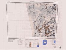
Kirkwood Range
[2] Inland, the Convoy Range lies to the southwest, terminating in Mount Douglas at the head of the Fry Glacier.
Discovered by the British National Antarctic Expedition (BrNAE) (1901-04) which named this feature after Professor Carl Friedrich Gauss (1775-1855), German mathematician and astronomer.
Discovered by the BrNAE (1901-04) and named for Sir Peter Chetwynd, a naval friend of Scott's, who was later Superintendent of Compasses at the Admiralty.
Steep coastal cliffs and projecting ridges mark the east margin, but there is a gentle slope west from the massif's broad, plateaulike snow summit.
Following additional mapping by USGS in 1999 and consultation between US-ACAN and NZGB, the name of the south block of Kirkwood Range was amended to Endeavour Massif to provide terminology better suited to the complex nature of the feature.
A ridge 4 nautical miles (7.4 km; 4.6 mi) long that extends east from the north part of the Endeavour Massif.
[11] A more recent description from Antarctica New Zealand says it is a 1,810 metres (5,940 ft) summit, 1 mile (1.6 km) north of the base of Ketchum Ridge in the south part of Endeavour Massif.
Following additional mapping by USGS in 1999 and consultation between US-ACAN and NZGB, the name Endeavour Massif was approved for the south block of the Kirkwood Range.
A glacier that flows east from Endeavour Massif along the north side of Ketchum Ridge to Tripp Ice Tongue.
Named after Lieutenant Commander Glenn F. Glezen, U.S. Navy (USN), Administrative Officer, Task Force 43, on Operation Deep Freeze I and IV, 1955-56 and 1958-59.
A prominent rock summit that rises over 1,200 metres (3,900 ft) about 1.5 nautical miles (2.8 km; 1.7 mi) west of Mount Creak.
A sharp peak, 1,240 metres (4,070 ft) high, just north of Shoulder Mountain in the south end of the Kirkwood Range.
A prominent peak over 600 metres (2,000 ft) high, located at the end of the ridge 2 nautical miles (3.7 km; 2.3 mi) east of Mount Creak in the southeast extremity of Endeavor Massif.
A prominent, triangular rock buttress over 1,000 metres (3,300 ft) high, on the north side of the lower Fry Glacier and close south of Mount Creak.