Mount Edziza
Mount Edziza (/ədˈzaɪzə/ əd-ZY-zə; Tahltan: Tenh Dẕetle [ten̥ ˈdðetle]) is a volcanic mountain in Cassiar Land District of northwestern British Columbia, Canada.
The form of the name was also changed to reflect entrenched local usage and in conformation with Mount Edziza Provincial Park, which was established in 1972.
[2][5][12] It lies at the northern end of the Mount Edziza volcanic complex which also includes the smaller Arctic Lake and Kitsu plateaus to the south.
[14][15] Mount Edziza is in the Southern Boreal Plateau Ecosection which consists of several upland summits, wide river valleys and deeply incised plateaus.
[26][27] This warming trend ceased about 2,600 years ago, causing glaciers to advance from Mount Edziza and elsewhere along the volcanic complex as a part of the neoglaciation.
This rapid glacial recession is apparent from the lack of vegetation on the barren, rocky ground between the glaciers and their trim lines which are up to 2 km (1.2 mi) apart.
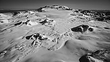
[1][14] It has been considered by some to be the highest or tallest volcano in Canada, but others have given higher elevations of 2,860 and 3,160 m (9,380 and 10,370 ft) for the Silverthrone volcanic complex in southwestern British Columbia.
[38] The central, 2,786 m (9,140 ft) high edifice of Mount Edziza is a nearly symmetrical stratovolcano, its symmetry having been broken by several steep-sided lava domes.
[36] Along the north side of Tenchen Valley on the eastern flank of the stratovolcano are 850 m (2,790 ft) high cliffs exposing explosion breccias, trachyte lavas and landslide or lahar deposits.
[8][41] This prominent pyramid-shaped horn has an elevation of 2,500 m (8,200 ft) and is the glacially eroded remains of an older stratovolcano whose northern flank is buried under the younger edifice of Mount Edziza.
[47][61] The Desolation Lava Field contains at least 10 cinder cones, most of which are clustered near the northern trim line of Mount Edziza's ice cap.
[5][78] Mount Edziza is part of the Northern Cordilleran Volcanic Province, a broad area of shield volcanoes, lava domes, cinder cones and stratovolcanoes extending from northwestern British Columbia northwards through Yukon into easternmost Alaska.
[79] The dominant rocks comprising these volcanoes are alkali basalts and hawaiites, but nephelinite, basanite and peralkaline[b] phonolite, trachyte and comendite are locally abundant.
[51] From Cartoona Ridge north to Tennaya Creek are isolated remnants of Pharaoh Dome, the main mass of which comprises flow-layered rhyolite and is buried under basalt of the Ice Peak Formation.
[104][105] Ice Peak Formation basalt flows on the northwestern flank of Mount Edziza are interbedded with diamictites recording a regional glaciation that occurred during the Early Pleistocene.
[106] The lowermost basalt flow contains basal pillows, directly overlies hyaloclastites and is brecciated and deformed, suggesting it may have been extruded onto a glacier or an ice sheet.
[43][106] Its extrusion onto glacial ice is also evident due to the lack of fluvial and lacustrine sediments at the base of the basalt flow which suggests it did not extrude into lakes or streams.
[106] The steep sides and unusually large thicknesses of the trachyte flows comprising Koosick and Ornostay bluffs is attributed to them having been extruded through glacial ice.
[121] The source of this Kakiddi flow remains unknown, but the tributary branch that descended Tennaya Valley probably originated from a vent near the summit of Ice Peak that is now covered by glaciers.
[123] A relatively small trachyte flow descended from Punch Cone on the western flank of Ice Peak and spread onto the Big Raven Plateau.
[126] All of these features consist of alkali basalt and hawaiite with the exception of the Sheep Track Member which comprises a small volume of trachyte pumice.
These tuff rings, composed of quenched breccia, later transitioned into normal subaerial cinder cones as the progressing eruptions displaced ice and meltwater.
Basalt flows and pyroclastic rocks of this Pliocene geological member are exposed north of Raspberry Pass on the eastern and western flanks of Mount Edziza.
[8][132] Much of the Tenchen Member as well as the southern edge of the Ice Peak volcanic pile are underlain by the Armadillo Formation which consists of Miocene comendite, trachyte and alkali basalt.
[8][91] Most of Mount Edziza is also underlain by Miocene basalt flows of the Raspberry Formation which form the base of prominent escarpments east and west of the mountain.
[8][133] These geological formations are underlain by the Stikinia terrane, a Paleozoic and Mesozoic suite of volcanic and sedimentary rocks that accreted to the continental margin of North America during the Jurassic.
The Canadian National Seismograph Network has been established to monitor earthquakes throughout Canada, but it is too far away to provide an accurate indication of activity under the mountain.
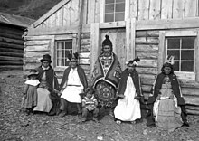
The obsidian from this portion of our territory provided us with weaponry, tools and trading goods that ensured our Tahltan people could thrive for thousands of years.
[153] Mineral exploration on the Spectrum property began as early as 1957 when Torbit Silver Mines performed surface work on the gold-bearing Hawk vein.
[160] The trail enters Mount Edziza Provincial Park at about 25 km (16 mi) where Kakiddi Creek drains into the Klastline River.