Big Raven Plateau
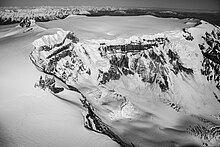
The dominant feature on the Big Raven Plateau is Mount Edziza, an ice-covered stratovolcano reaching an elevation of 2,786 metres (9,140 feet).
[2] The Big Raven Plateau lies at the northern end of the Mount Edziza volcanic complex, which consists of a group of overlapping shield volcanoes, stratovolcanoes, lava domes and cinder cones that have formed over the last 7.5 million years.
[10][11] In addition to the Big Raven Plateau, the volcanic complex also includes the Arctic Lake and Kitsu plateaus, as well as the Spectrum Range to the south.
[2][12][13] As a part of the Mount Edziza volcanic complex, the Big Raven Plateau is drained entirely by streams within the Stikine River watershed.
[5] In contrast to the northern end of the Big Raven Plateau which is relatively smooth and uneroded, the eastern side has undergone extensive erosion which has resulted in the creation of steep spurs with intervening valleys.
Discharge at these hot springs may be linked to shallow hydrothermal systems driven by residual magmatic heat as they are adjacent to recently active volcanic centres on the plateau.
[2][5][26] Mount Edziza is a nearly symmetrical volcanic cone containing a nearly flat summit with an ice-filled, 2 km (1.2 mi) in diameter crater.
[5][32] This prominent pyramid-shaped horn has an elevation of 2,500 m (8,200 ft) and is the glacially eroded remains of an older stratovolcano whose northern flank is buried under the younger edifice of Mount Edziza.
[35] The largest lava flow is about 14 km (8.7 mi) long and travelled to the northeast into the Kakiddi Creek and Klastline River valleys where it temporarily blocked both streams.
[30][37] Williams Cone is the largest, reaching 1.2 km (0.75 mi) wide at its base and rising about 275 m (902 ft) on the northeastern side of Mount Edziza.
[5][41] Nearly all of these vents are adjacent to the lower edges of broad glaciers projecting from Mount Edziza's ice cap and occur at elevations greater than 1,800 m (5,900 ft).
[4][5] The Raspberry Formation is exposed at the base of prominent escarpments on the western, southwestern and southeastern sides of the Big Raven Plateau.
[50] More than 180 m (590 ft) of Raspberry lava flows are exposed in the Mess Creek Escarpment, most of which were erupted from a shield volcano that formed on a Late Miocene erosion surface.
[51][52] These lava flows travelled westward into the ancestral valley of Mess Creek while those exposed on and around Cartoona Ridge at the southeastern end of the Big Raven Plateau most likely issued from a smaller volcanic centre northeast of the Raspberry shield.
[56] In contrast, the air-fall pumice and ash flows probably originated from the more than 4 km (2.5 mi) in diameter Armadillo Peak caldera south of the Big Raven Plateau.
[5] Alkali basalt of the Gamma Peak eruptive centre is in the form of lava flows, tuff breccia and pillow lava which occur in the upper canyon of Elwyn Creek at the northwestern end of the Big Raven Plateau and overlie alkali basalt of the lower unit at the southeastern end of the plateau.
[2][59] Exposures of the 1.1-million year-old Pyramid Formation are limited only to the northeastern, eastern and southeastern ends of the Big Raven Plateau where it is in the form of rhyolite and trachyte domes, flows and pyroclastic breccia.
[5][60] The Pyramid at the northeastern end of the plateau consists of a roughly 366 m (1,201 ft) high trachyte dome whose base is slightly more than 1 km (0.62 mi) wide.
[63] Isolated remnants of the rhyolitic Pharaoh Dome occur along the eastern and southeastern ends of the Big Raven Plateau between Tennaya Creek in the north and Cartoona Ridge in the south.
[5] Alkali basalt, trachybasalt, tristanite, mugearite, benmoreite and trachyte of the upper assemblage are in the form of lava flows, domes and pyroclastic breccia.
They comprise the summit of Ice Peak and are exposed to the south and northeast along the southeastern and eastern sides of the Big Raven Plateau.
[5] Ornostay and Koosick bluffs on the western flank of Ice Peak consist of thick lobes of trachyte of the upper assemblage and project onto the Big Raven Plateau.
[5][29] Exposed at the head of this cirque is hydrothermally altered vent breccia of the central conduit which is overlain by the remains of at least four lava lakes that ponded inside the summit crater.
[77] An unnamed pyroclastic cone on the northwestern flank of Mount Edziza produced two trachyte flows that travelled onto the gently sloping surface of the Big Raven Plateau; they are both largely buried under ash and colluvium deposits.
[5][78] The Klastline Formation consists of the remains of thick alkali basalt flows that issued from at least three vents on the northern and eastern sides of the Big Raven Plateau 0.62 million years ago.
[5][80] The 0.3-million-year-old Kakiddi Formation occurs east and west of Tencho Glacier on the southern flank of Ice Peak, consisting mainly of trachyte in the form of pyroclastic rocks and lava flows.
[5][81] Punch Cone on the southwestern flank of Ice Peak is a roughly 1 km (0.62 mi) long, steep-sided ridge composed of agglutinated Kakiddi spatter and breccia from which a largely buried lava flow extends westward onto the gently sloping surface of the Big Raven Plateau.
[5][88] The Big Raven Formation also includes the Sheep Track Member, a pyroclastic fall deposit of unconsolidated comenditic trachyte pumice obscuring much of the surficial details of the Snowshoe Lava Field.
[5] All of these Eocene rocks are part of the Sloko Group and were emplaced by the youngest documented magmatic event before the Mount Edziza volcanic complex started erupting in the Late Miocene.
[100] The trail enters Mount Edziza Provincial Park at about 25 km (16 mi) where Kakiddi Creek drains into the Klastline River.