Mount Moulton
The Prahl Crags are located on the southern slopes of Mount Moulton and are part of a caldera.
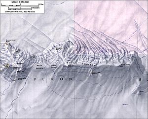
Mount Moulton lies in Marie Byrd Land[1] of Western Antarctica and in the region of the West Antarctic Ice Sheet.
[2] The volcano is named for Richard S. Moulton, chief dog driver of the United States Antarctic Service Expedition;[3] the western end of the Flood Range[3] where Mount Moulton lies[4] was visited by this expedition in December 1940.
[2] Earthquakes have been recorded at Mount Moulton and are either of volcano-tectonic origin or due to the movement of ice along the flanks of the volcano.
[12] The calderas are 8 kilometres (5.0 mi) apart[14] and located at the Prahl Crags, Britt Peak and potentially Kohler Dome localities.
[12] Additionally the Prahl Crags – remnants of the former caldera rim – are found south, Gawne Nunatak west, Edwards Spur northeast and the Moulton Icefalls on the northern side of the mountain.