Paektu Mountain
[needs update] The mountain is considered culturally important to multiple groups in the area, including Korean, Chinese, and Manchu people.
According to the Song dynasty travelogue Songmo Jiwen, it was named as such because the mountain was "the abode of the white-robed Guanyin" and its birds and beasts were all white.
[citation needed] The Korean name Baekdusan / Paektusan (백두산; 白頭山) first appears in literature in the 10th year of Seongjong of Goryeo (991) in the Goryeosa, compiled at the beginning of the Joseon period.
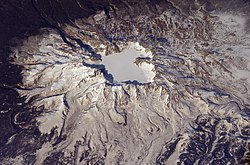
The caldera is about 5 km (3.1 mi) wide and 850 meters (2,790 ft) deep, and is partially filled by the waters of Heaven Lake.
The construction of the cone of the volcano began approximately 1 million years ago, as the eruptive materials transitioned into trachytic pyroclastic and lava flows.
During the cone-construction stage, major Plinian-type eruptions occurred 448, 67.6, 85.8 and 24.5 thousand years ago (ka) and deposited ash in the Japan sea.
[22] The eruption, whose tephra has been found in the southern part of Hokkaidō, Japan, and as far away as Greenland,[23] destroyed much of the volcano's summit, leaving a caldera that today is filled by Heaven Lake.
According to the Korean historical record Goryeosa, in 946 "thunders from heaven's drum" were heard in the city of Kaesong, then the capital of Goryeo, about 450 km (280 mi) south of the volcano.
[24] According to the Heungboksa Temple's historical records, on 3 November, "white ash rain" fell in Nara, Japan, about 1,100 km (680 mi) southeast from the mountain[24] Three months later, on 7 February 947, explosive noises were reported in the city of Kyoto (Japan), about 1,000 km (620 mi) southeast of Paektu.
[25][26] The Government of North Korea invited several volcanologists, including James Hammond, Clive Oppenheimer, and Kayla Iacovino, to study the mountain for recent volcanic activity.
The mountain has been identified by BirdLife International as an Important Bird Area (IBA) because it supports a population of scaly-sided mergansers.
[35] According to Korean mythology, it was the birthplace of Dangun, the founder of Gojoseon (2333–108 BC), whose parents were said to be Hwanung, the Son of Heaven, and Ungnyeo, a bear who had been transformed into a woman.
In the 15th century, King Sejong strengthened the fortification along the Tumen and Yalu rivers, making the mountain a natural border with the northern peoples.
[40] Some Koreans claim that the entire region near Mount Paektu and the Tumen River belongs to Korea and parts of it were illegally given away by Japanese colonialists to China through the Gando Convention.
[citation needed] Mount Baekdu is mentioned in the national anthems of both North and South Korea and in the Korean folk song "Arirang".
"[45] North Korean media celebrates natural phenomena witnessed at the mountain as portentous,[46] and weather forecasts aired by state broadcaster Korean Central Television list Paektusan Secret Camp, claimed birthplace of Kim Jong Il, behind only the capital of Pyongyang.
[51] In the popular strategy game Europa Universalis 4 the mountain appears as part of a Korean mission entitled "Access to Mt.
[53] The Jin dynasty bestowed the title "the King Who Makes the Nation Prosperous and Answers with Miracles" (興國靈應王) on the mountain in 1172 and it was entitled "the Emperor Who Cleared the Sky with Tremendous Sagehood" (開天宏聖帝) in 1193.
[8] The Manchu clan Aisin Gioro, which founded the Qing dynasty of China, claimed their progenitor Bukūri Yongšon was conceived near Paektu Mountain.
The Kangxi Emperor claimed that Mount Tai and Changbai belong to the same mountain range, which runs from northeast to southwest but is partially submerged under the sea before reaching Shandong.
The geography and feng shui of Mount Changbai thus provided legitimacy to the Aisin Gioro clan's rule over China.
[53] Baishan Heishui, "white mountain and black river", referring to Mount Changbai and the Heilongjiang, has been a traditional name for Northeast China since the Jin dynasty.
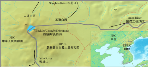
To mark the agreement, they built a monument describing the boundary at a watershed, near the south of the crater lake at the mountain peak.
[citation needed] The 1909 Gando Convention between China and Japan, when Korea was under Japanese rule, recognized the north and east of the mountain as Chinese territory.
As a result of the treaties, North Korea received 280 km2 (110 sq mi)[57] of land on and around Paektu, 9 out of 16 peaks, and 54.5% of Heaven Lake.
[60] However, some South Korean groups argue that recent activities conducted on the Chinese side of the border, such as economic development, cultural festivals, infrastructure development, promotion of the tourism industry, attempts at registration as a World Heritage Site, and bids for a Winter Olympic Games, constitute attempts to claim the mountain as Chinese territory.
[citation needed] Pegae Hill is a camp site of the Korean People's Revolutionary Army [ko] allegedly led by Kim Il Sung during their struggle against Japanese colonial rule.