Mount Pinos
Mount Pinos (/ˈpaɪnoʊs/) (Samala: 'Iwɨhɨnmu) is a mountain located in the Los Padres National Forest on the boundary between Ventura and Kern counties in California.
The trace of the San Andreas Fault, clearly visible to the northwest, cuts between Mount Pinos and the mountains immediately to the north.
The area experiences several feet of snow each year with snowfields lasting till early June on the north facing slopes.
[6] It is also home to alpine endemics such as the mountain quail, Clark's nutcracker, Steller's jay and pygmy nuthatch (best seen in campground), as well as hermit warbler (typical during migration) and green-tailed towhee.
[citation needed] The mountain is sacred to all Native Americans in California, according to Arianne Chow-Garcia, chair of the Chalon Indian Council of Bakersfield.
John Pryor, professor of anthropology and archaeology at California State University, Fresno, said that the land "is continuing to be used for ceremony.
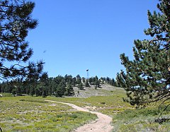
From the Chula Vista parking lot a trail network spreads both uphill towards Condor Point and downhill reaching as far as McGill Campground.
Skiing and boarding are also available in backcountry bowls on the north face of the peak and ridges that drop all the way down the mountain to about the 6,000-foot (1,828.8 m) level.
In such cases it is common for the Kern County Roads Department to close a snow gate lower on the mountain.
Snow at lower elevations also facilitates cross country skiing to Iris Point which provides great views of Lockwood Valley.
Mount Pinos is considered to be one of the best viewing sites in Southern California due to its relatively low light pollution, dry air and frequently clear skies contributing to good astronomical seeing.