Mount Rinjani
[7] Rinjani is one of at least 129 active volcanoes in Indonesia, four of which belong to the volcanoes of the Sunda Arc trench system forming part of the Pacific Ring of Fire – a section of fault lines stretching from the Western Hemisphere through Japan and South East Asia.
Rice, soybeans, coffee, tobacco, cotton, cinnamon, cacao, cloves, cassava, corn, coconuts, copra, bananas and vanilla are the major crops grown in the fertile soils of the island.
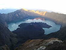
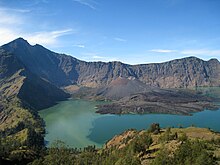
Rinjani has a steep-sided conical profile when viewed from the east, but the western side of the compound volcano is truncated by the 6 x 8.5 km, oval-shaped Segara Anak caldera.
[9] On the basis of the plate tectonics theory, Rinjani is one of the series of volcanoes built in the Lesser Sunda Islands due to the subduction of Indo-Australian oceanic crust beneath the Lesser Sunda Islands, and it is interpreted that the source of melted magma is about 165–200 kilometres (103–124 mi) depth.
The islands are located on the eastern edge of the Sunda shelf, in a zone where crustal thickness is apparently rapidly diminishing, from west to east.
[13] The seismic velocity structure of the crust in this region is transitional between typical oceanic and continental profiles and the Mohorovičić discontinuity (Moho) appears to lie at about 20 kilometres (12 mi) depth.
[14] These factors tend to suggest that there has been limited opportunity for crustal contamination of magmas erupted on the islands of Lombok and Sumbawa.
This is considered to be a feature representing a major tectonic discontinuity between the east and west Sunda Arcs (the Sumba Fracture).
Dated to "late spring or summer of 1257," this 1257 Samalas eruption is now considered the likely source of high concentrations of sulfur found in widely dispersed ice core samples and may have been "the most powerful volcanic blast since humans learned to write.
Historical eruptions at Rinjani dating back to 1847 have been restricted to Barujari cone and the Rombongan dome (in 1944) and consist of moderate explosive activity and occasional lava flows that have entered Segara Anak lake.
[24] The eruptive history of Rinjani prior to 1847 is not available as the island of Lombok is in a location that remained very remote to the record keeping of the era.
On 3 November 1994, a cold lahar (volcanic mudflow) from the summit area of Rinjani volcano traveled down the Kokok Jenggak River killing thirty people from the village of Aikmel who were caught by surprise when collecting water from the river in the path of the flow.
Geochemical models suggest that fractional crystallization is an important process in the suite's differentiation, although the series: ankaramite-high-Al basalt-andesite-dacite does not represent a continuously evolving spectrum of liquids.
A NOTAM about volcanic activity from Rinjani was issued by the Bali Flight Information Region on the morning of 12 September.
[32] During 4 June 1994 – January 1995 the DVGHM (Directorate of Volcanology and Geological Hazard Mitigation) noted that explosions occurred on Rinjani.
[33] Between 3 June 1994 and 21 November 1994 records of Rinjani's eruptive history indicate activity accorded Volcanic Explosivity Index (VEI) with a rating of 3(?)
[34] In May 1994 a glow was noticed on the crater floor of Barujari cone, which at this time had undergone no significant activity since August 1966.
One 8 June 1994 press report described emission of "smoldering lava" and "thick smoke," as well as ashfall in nearby villages from an ash cloud rising 1,500 m (4,900 ft) above the summit.
Between 3 and 10 June 1994, up to 172 explosions could be heard each day from the Sembalun Lawang volcano observatory (about 15 km (9.3 mi) NE).
[35] Between 28 March 1966 and 8 August 1966 records of Rinjani's eruptive history indicate activity accorded a Volcanic Explosivity Index (VEI) rating of 1.
January 1945 eruptive activity is rated 2 on the Volcanic Explosivity Index (VEI) The event has been listed in the historical records of the Global Volcanism Program indicating a lava volume: of 74×10^6 m3 (2.6×10^9 cu ft) occurring in an area of activity on the north west flank of Barujari (Rombongan).
According to the volcano's official monitoring agency, ash from Mount Rinjani was reported as rising up to two kilometers into the atmosphere and damaged crops.
[43] The activity in early 2010 centred about Gunung Barujari, a post-caldera cone that lies within the Rinjani's caldera lake of Segara Anak.
The Volcanological Survey of Indonesia reported on 1 May 2010, that a column of smoke was observed rising from G. Rinjani "issuing eruptions 1300–1600 metres tall with thick brown color and strong pressure".
CVGHM (Center of Volcanology and Geological Hazard Mitigation) advised the VAAC that intermittent activity could produce ash plumes to 1.5 km (4,900 ft) above the caldera.
[48] On 5 August 2018, a second earthquake struck Lombok, causing more landslides and small tsunamis due to its proximity to the northern coast.
The park is popular for mountain climbs and trekking and represents an important nature reserve and water catchment area.