NAVTEX
[1] NAVTEX was developed in the late 1970s in northwestern Europe to provide a low-cost, simple, and automated means of receiving this information aboard ships at sea within approximately 250 nautical miles (460 km) off-shore.
NAVTEX is a component of the International Maritime Organization/International Hydrographic Organization Worldwide Navigation Warning Service (WWNWS).
NAVTEX Marine Safety Information (MSI) national transmissions also take place on HF at 4209.5 kHz using FEC mode.
The subject indicator characters B, F and G are normally not used in the United States since the National Weather Service normally includes meteorological warnings in forecast messages.
Meteorological warnings are broadcast using the subject indicator character E. U.S. Coast Guard District Broadcast Notices to Mariners affecting ships outside the line of demarcation, and inside the line of demarcation in areas where deep draft vessels operate, use the subject indicator character A.
Within each time slot, a mix of navigation warnings, weather forecasts, ice information and other content may be sent, and this is normally according to a structured plan for that specific station.
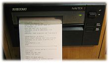
Details of all transmitting stations and their schedules may be found at [1] NAVTEX receivers which are approved for GMDSS contain an internal printer and/or a scrollable display, and cost between $800–$1500.
A new generation of NAVTEX receivers intended for non-GMDSS applications such as the recreational community is entering the marketplace.
There are also a number of software packages available (SeaTTY, Mscan, JNX, Fldigi or JVComm32 are examples) that allow messages NAVTEX to be decoded by on a personal computer connected to a receiver that covers the medium frequency range.
In September 2019, the U.S. Coast Guard proposed shutting down its MF NAVTEX services and relying on satellite communications.