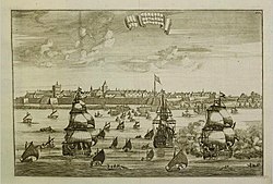
Nagapattinam Port
The port and the lighthouse are maintained by the Tamil Nadu Maritime Board under the Government of India.
[2] Till Tsunami in 2004, a small bridge connected a village named Keechakuppam with Nagapattinam town.
The construction of an expanded and an elevated bridge was completed after 2008, which enabled the expansion of the port as well as the fishing harbour.
As is the case with the Kaveri river tributaries, the estuarine portion of the mouth of Kudavayyar to Bay of Bengal is shallow.
Ten villages were transferred from the Portuguese to the Dutch – Nagapattinam Port, Puthur, Muttam, Poruvalancheri, Anthanappettai, Karureppankadu, AzhingiMangalam, Sangamangalam, Thiruthinamangalam, Manjakollai, Nariyankudi.
[1] Most of the principal exports to Sri Lanka from the port during the British period were rice, piece goods, live stock, cigars, tobacco and skin.
The trade of Nagapattinam was mostly with Ceylon, Straits Settlements, Burma and to a small extent to the United Kingdom and Spain.
[1] The port has been planned to have a green field, all weather and enhancing capacity to handle 10 lakh tonnes of cargo every year, but the expansion has been opposed by fishing community.
The central government plan to convert the port into an economic zone under Sagar Mala project is also opposed by the fishing community fearing restrictions.