Nahe (Rhine)
Due to this relatively large area compared to the river's length high floods can occur along its middle and lower course within only a few hours, however flowing off also quickly.
Its boundaries clock-wise, beginning in the East: The rocks in the Nahe region are predominantly of Cisuralian (early Permian) age and part of the Rotliegendes.
The valleys of the Nahe and its tributaries have been being formed since 2.6 million years ago during the Quaternary, the geologically latest period, as a result of ground heaving of the surrounding mountains of Hunsrück and North Palatine Uplands.
Particularly strong erosion occurred in warmer melting periods during the ice ages, when tundra climate reigned, and the soil was not protected by a dense cover of vegetation.
These plants immigrated in a postglacial warm period to Europe but became extinct in most regions when the climate changed again to significantly cooler and more humid conditions.
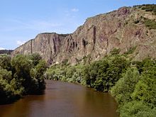
In the Nahe valley and its tributaries these are mostly rocky precipices towards South or South-East, furthermore sunny slopes with shrubs, bushes and dry broad-leaved forests.
For instance can be mentioned the "Hellberg" near Kirn, the "Flachsberg" near Martinstein, the "Heimberg" near Waldböckelheim, the "Gangelsberg" near Duchroth and the "Rotenfels" as well as the "Rheingrafenstein" near Bad Münster am Stein.
The monastery ruin of Disibodenberg, located on top of a hill between the junction of the Nahe and the Glan, was founded at the beginning of the 8th century by Saint Disibod, an Irish missionary.
Some 40 kilometres (25 mi) to the north the Frankfurt-Hahn Airport is in the Hunsrück, offering daily flights to London Stansted and further weekly and seasonal connections.