Nahta Cone
The summit of the cone contains a circular crater breached on the east which was the source of a roughly 3-kilometre-long (1.9-mile) lava flow that travelled northerly and then westerly into the head of Nahta Creek.
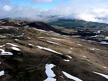
Nahta Cone is located in Cassiar Land District of northwestern British Columbia, Canada, near the northern edge of the Arctic Lake Plateau.
[6][9] Nahta Cone lies in the southwestern corner of Mount Edziza Provincial Park about 70 kilometres (43 miles) south-southeast of the community of Telegraph Creek.
[11][12] Mount Edziza Provincial Park is in the Tahltan Highland, a southeast-trending upland area extending along the western side of the Stikine Plateau.
[7][19] Erosion has unmodified the blocky surface of the lava flow, but Nahta Creek at its distal end has begun to etch a new channel where it displaced the stream.
[22][23][24][25][26] In his 1992 report The Late Cenozoic Mount Edziza Volcanic Complex, British Columbia, Jack Souther gave Nahta Cone the numeronym AL-1.