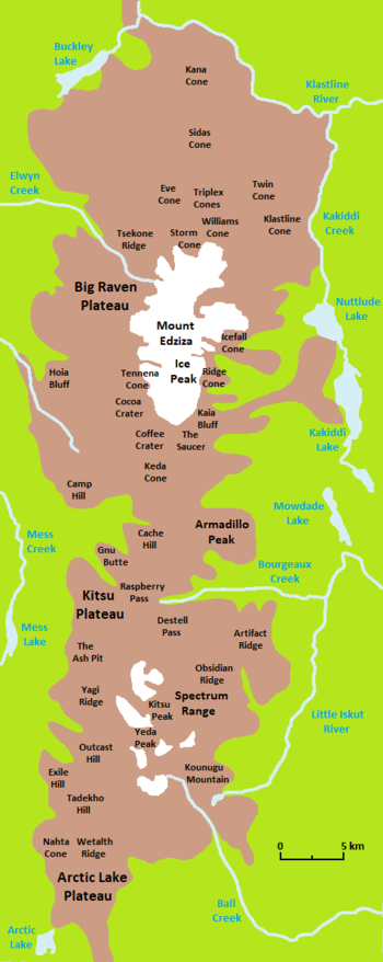
Spectrum Range
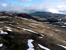
The mountain range is drained on all sides by streams within the Stikine River watershed and, unlike Mount Edziza to the north, contains relatively small separate glaciers.
[6][17] Extending outward from the central portion of this nearly circular group of pyramidal peaks and long, narrow-creasted ridges is a crudely radial drainage system characterized by deeply incised valleys.
[1] It was also originally higher than its current elevation of 2,430 metres (7,970 feet) as evidenced by the thick, gently dipping lava flows comprising the summit of Kitsu Peak, the highest point of the Spectrum Range.
[1] As a part of the Mount Edziza volcanic complex, the Spectrum Range was covered by a regional ice sheet during the Pleistocene which receded and advanced periodically until about 11,000 years ago when deglaciation was essentially complete in a steadily warming climate.
The present trend towards a more moderate climate put an end to the neoglacial period in the 19th century; this has resulted in rapid glacial recession throughout the Mount Edziza volcanic complex.
[21] Unlike Mount Edziza, which has an approximately 70-square-kilometre (27-square-mile) ice cap, the Spectrum Range is covered with relatively small separate glaciers that occupy cirques on most peaks greater than 2,130 m (6,990 ft) in elevation.
[6][28] The Spectrum Range is part of the Northern Cordilleran Volcanic Province, a broad area of volcanoes and lava flows extending from northwestern British Columbia northwards through Yukon into easternmost Alaska.
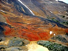
[32] Basaltic lava flows of this Pliocene geological member are exposed around the perimeter of the Spectrum Range and are limited only to the area south of the broad east–west valley of Raspberry Pass.
[36] The Nido and Raspberry formations are underlain by the Stikinia terrane, a Paleozoic and Mesozoic suite of volcanic and sedimentary rocks that accreted to the continental margin of North America during the Jurassic.
It occurs within a roughly circular area about 10 km (6.2 mi) in diameter and likely formed by collapse of a shallow magma chamber during eruption of the Spectrum Formation lavas.
[6][47] Some of the ejecta accumulated around the vent to form a low volcanic cone while the more volatile, pumice-rich phases of the eruption sent ash flows down the slopes of the Spectrum Dome.
[45] Renewed volcanism at Exile Hill 8 km (5.0 mi) to the west on the Arctic Lake Plateau produced a similar but much smaller eruption that created a roughly 200 m (660 ft) wide breccia pipe.
[6][48] Late-stage volcanism also deposited alkali basalt flows of the Kitsu Member which likely issued from multiple eruptive centres on the dome's summit that have since been removed by erosion.
[50][51] About 4 km (2.5 mi) to the south, Tadekho Hill formed on top of a 180 m (590 ft) high remnant of Spectrum Formation trachyte and produced lava flows which spread onto the surrounding plateau surface.
[54] Volcanism during the Holocene created subaerial cinder cones and lava flows on the northwestern and southwestern sides of the Spectrum Range, all of which are part of the Big Raven Formation.
[55] The youngest cinder cone, The Ash Pit, formed at the south end of the Mess Lake Lava Field and was the source of a northeasterly-trending tephra deposit on the Kitsu Plateau.
[5][60] At the head of Ball Creek valley is a subvolcanic mass of granite with abnormally high soda content that probably intruded into the base of the Spectrum Dome during the explosive Yeda Peak breccia pipe eruption.
It lies along the edge of the hypothetical caldera or irregular collapse structure and comprises a series of glacially rounded bluffs along the southwestern side of Ball Creek valley.
The soda granite forming this subvolcanic intrusion is lustrous brown and medium to coarse-grained, consisting mostly of feldspar that is locally covered with iron and manganese oxides.