Namib
From the Atlantic coast eastward, the Namib gradually ascends in elevation, reaching up to 200 kilometres (120 mi) inland to the foot of the Great Escarpment.
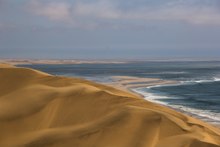
[A] The desert geology consists of sand seas near the coast, while gravel plains and scattered mountain outcrops occur further inland.
The Namib is almost completely uninhabited by humans except for several small settlements and indigenous pastoral groups, including the Ovahimba and Obatjimba Herero in the north, and the Topnaar Nama in the central region.
Although the outer Namib is largely barren of vegetation, lichens and succulents are found in coastal areas, while grasses, shrubs, and ephemeral plants thrive near the escarpment.
It occupies an area of around 80,950 square kilometres (31,250 sq mi),[9] stretching from the Uniab River (north) to the town of Lüderitz (south) and from the Atlantic Ocean (west) to the Namib Escarpment (east).
To the north, the desert leads into the Kaokoveld; the dividing line between these two regions is roughly at the latitude of the city of Walvis Bay, and it consists in a narrow strip of land (about 50 km wide) that is the driest place in Southern Africa.
[2] The Namib's aridity is caused by the descent of dry air of the Hadley cell, cooled by the cold Benguela Current along the coast.
Winds coming from the Indian Ocean lose part of their humidity when passing the Drakensberg mountains, and are essentially dry when they reach the Namib Escarpment at the eastern end of the desert.
Some of these wrecked ships can be found as much as 50 metres (55 yards) inland, as the desert slowly moves westwards into the sea, reclaiming land over many years.
Benguela's El Niño (similar to the Pacific event in its environmental change in the seas) spreads from the Kunene estuary southward to, on occasion, south of Luderitz.
Welwitschia is notable for its survival in the extremely arid Namib conditions, made possible by its ability to capture moisture from coastal sea fogs.
[12] "Fairy circles", which are circular patches of land barren of plants, varying between 22 and 12 metres (7 and 39 ft) in diameter and often encircled by a ring of stimulated growth of grass, are found in the Namib,[13] such as those near the Wolwedans desert camp.
Before the 20th century, some San roamed the Namib, gathering edible plants on the shore, hunting in the interior, and drinking the juice of the tsamma melon for water.
[16] The steppes in the southern half of the desert are mostly made up of ranches run by Europeans, who raise Karakul sheep with local help and send the pelts of the lambs to Europe for use in fur coats.
A vast portion of the desert, called the Sperrgebiet, was access-restricted due to the presence of diamonds, which are mined in the area at the mouth of the Orange River.
[17] In 2019 the Namibian-German artist Max Siedentopf created an installation in the Namib consisting of a ring of large white blocks atop of which sit six speakers attached to a solar-powered MP3 player configured to continuously play the 1982 song "Africa" by the American band Toto.
The prominent attraction is the Sossusvlei area, where high orange sand dunes surround vivid white salt pans, creating a fascinating landscape.