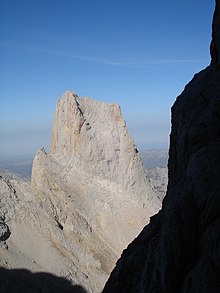
Naranjo de Bulnes
The first written reference to "Picu Urriellu" as "Naranjo de Bulnes" is credited to the German geologist and engineer, Wilhelm Schulz, who, in 1855, published the first topographic and geological map of Asturias.
The local residents of Bulnes have a saying concerning the contentious name: "No me llameis Naranjo, pues fruto no puedo dar, llamadme Picu Urriellu que es mi nombre natural".
Using the same face and route as Pidal, Victor Martínez Campillo, a local of the nearby town of Bulnes, made the ascent on 31 August 1916.
On this climb, Campillo recovered parts of the rope that Pidal and Perez had left attached to the rock during their descent from the peak.
He made the same climb again on 22 September 1923, and on 19 August 1924, also opened a more gentle route, located to the left of the south face and now known as Vía Victor.
One month later, on 8 August, Manuel Martinez Campillo (a cousin of Victor) opened a new path known as the Horizontal Pass.
On 23 March 1954, Antonio Moreno, Rafael Pellús, Máximo Serna and Agustín Faus from the Peñalara High Mountain Group tried to make the first winter climb.
On 21 August 1962, the Aragonese mountaineers Alberto Rabadá and Ernesto Navarro completed the first ascent via the difficult West Face.
On 8 February 1973, two parties, one formed by Miguel Ángel García Gallego (from Murcia) and José Ángel Lucas, and the other formed by César Pérez de Tudela and Pedro Antonio Ortega (from Ardilla), made the first winter climb using the "Vía Rabadá y Navarro" on the West Face.
On 4 September 2009, the brothers Iker and Eneko Pou conquered Urriellu in 8 hours via the Orbayu route, a path with one of the most difficult cliff faces in the world with a gradient of 8c+/9a.
Although the most direct way of getting to the "Vega Urriellu" from Bulnes would be along the Balcosín channel and the "Majada de Camburero", this path is more difficult.