Narmada River
[11] The river descends from Sonmuda, then falls over a cliff as Kapildhara waterfall and meanders in the hills, flowing through a tortuous course crossing the rocks and islands up to the ruined palace of Ramnagar.
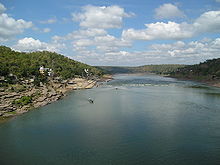
Between Ramnagar and Mandla, (25 km (15.5 mi)), further southeast, the course is comparatively straight with deep water devoid of rocky obstacles.
Beyond this point up to its meeting the Arabian Sea, the Narmada enters three narrow valleys between the Vindhya scarps in the north and the Satpura range in the South.
It is in the first valley of the Narmada that many of its important tributaries from the south join it and bring the waters of the northern slopes of the Satpura Hills.
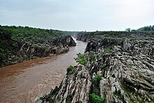
The early course of about 125 km (77.7 mi) up to Markari falls is met with a succession of cataracts and rapids from the elevated table land of Malwa to the low level of Gujarat plain.
The former joins at Rundh and the latter at Vyas in Vadodara district of Gujarat, opposite each other and form a Triveni (confluence of three rivers) on the Narmada.
The nearby island of Kabirvad, in the Narmada River, features a gigantic Banyan tree, which covers 10,000 square metres (2.5 acres).
[12] The Narmada basin, hemmed between Vindhya and Satpura ranges, extends over an area of 98,796 km2 (38,145.3 sq mi) and lies on the northern extremity of the Deccan Plateau.
At one time, a marine ravine penetrated the very centre of Peninsular India through a narrow inlet along the present valley of Narmada.
Such similarity probably suggests that even about 3 million years ago, Narmada and Tapi were confluent and the separate fate of these two rivers was decided by recent earth movements.
[24] Important towns of interest in the valley are Jabalpur, Barwaha, Narmadapuram, Harda, Narmada Nagar, Omkareshwar, Dewas (Nemavar, Kity, Pipri), Mandla and Maheshwar in Madhya Pradesh, and Rajpipla and Bharuch in Gujarat.
[25] The lower Narmada River Valley and the surrounding uplands, covering an area of 169,900 km2 (65,598.8 sq mi) consists of dry deciduous forests.
[citation needed] Tectona grandis is the dominant canopy tree, in association with Diospyros melanoxylon, Dhaora (Anogeissus latifolia), Lagerstroemia parviflora, Terminalia tomentosa, Lannea coromandelica, Hardwickia binata and Boswellia serrata.
The flora of the national park consists of mainly sal, teak, tendu, aonla, mahua, bael, bamboo, and a variety of grasses and medicinal plants.
[29][30] The Pachmarhi Biosphere Reserve covers part of three civil districts viz., Narmadapuram, Betul and Chhindwara of Madhya Pradesh.
It constitutes a large contiguous forest block that harbours a community of plant and animal species typical of the central highland region.
The Department of Archaeology, Museums and Archives, Government of Madhya Pradesh, undertook rescue excavations in response, and transplanted a number of temples.
[41][42] Investigations for harnessing the Narmada waters began in 1945 to 1946 by A. N. Khosla who was the chairman of the Central Waterways, Irrigation and Navigation Commission (CWINC).
[43] The Gujarat State government began planning studies for harnessing Narmada's water past the Punasa site in Madhya Pradesh.
This began inter-State conflicts that went on for several years until 1963 when the Chief Ministers of Madhya Pradesh and Gujarat arrived at a set of compromises called the Bhopal Agreement.
In 1965, the Committee prepared a Master Plan for the basin, which involved construction of 12 major projects in Madhya Pradesh and the Navagam Dam in Gujarat.
[43] After ten years of deliberations and taking into considering the development of the water resources of the basin as a whole gave its award December 1978.
[43] The social movement Narmada Bachao Andolan (NBA) was formed to address environmental concerns and rehabilitation and resettlement of affected people.
[45] This resulted in the Bank conducting an Independent Review Mission (IRM) in 1991 of the Sardar Sarovar Project and identified several recommendations.
Finally the Government of India decided to terminate further drawing from the World Bank loan and would complete the project with national resources.
[44] The Supreme Court has also deliberated on this issue for several years but finally upheld the Tribunal Award and allowed the construction to proceed, subject to conditions.
The Court introduced a mechanism to monitor the progress of resettlement pari passu with the raising of the height of the dam through Grievance Redressal Authorities (GRA) in each of the party states.
The Narmada canal has helped both states supply water to arid regions of Kutch and Saurashtra for irrigation purposes.
This Multipurpose River Valley Project envisages construction of a concrete gravity dam, 653 metres (2,142 ft) long and 92 metres (302 ft) high with gross storage capacity of the reservoir of 12.22 km3 (9,910,000 acre⋅ft) and live storage of 9.75 km3 (7,900,000 acre⋅ft) to provide an annual irrigation potential of 1,690 km2 (650 sq mi) and a generation of 1000 MW of hydropower.
[citation needed] The dam and the powerhouse have been completed, but storage has been restricted up to EL 260 m under orders of the High Court, Jabalpur from R&R consideration.