Native American tribes in Virginia
During English colonization and the formation of the United States, most Virginia tribes had lost their lands and their populations declined due to introduced diseases and warfare.
In 1542, Spanish explorer Hernando de Soto in his expedition to the North American continent encountered the Chisca people, who lived in present-day southwestern Virginia.
[9] Meanwhile, as early as 1559–60, the Spanish had explored Virginia, which they called Ajacán, from the Chesapeake Bay while they sought a water passage to the west.
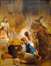
About ten years later, Don Luis returned with Spanish Jesuit missionaries to establish the short-lived Ajacán Mission.
According to colonial historian William Strachey, Chief Powhatan had slain the weroance at Kecoughtan in 1597, appointing his own young son Pochins as successor there.
According to their oral history, the Monacan, a Siouan-speaking people, settled in Virginia some 400 years earlier by following "an oracle," after being driven by enemies from the northwest.
The 17th-century historian William Strachey thought since bark was harder to acquire, families of higher status likely owned the bark-covered houses.
[16] In 1607, when the English made their first permanent settlement at Jamestown, Virginia, the area of the current state was occupied by numerous tribes of Algonquian, Siouan, and Iroquoian linguistic stock.
As they were separated by water from Powhatan's domains, the Accawmacke enjoyed some measure of semi-autonomy under their own paramount chief, Debedeavon, aka "The Laughing King".
In April 1613, Captain Samuel Argall learned that Powhatan's "favorite" daughter Pocahontas was residing in a Patawomeck village.
[25] The 1646 treaty delineated a racial frontier between Indian and English settlements, with members of each group forbidden to cross to the other side except by special pass obtained at one of the newly erected border forts.
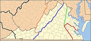
By this treaty, the extent of the Virginia Colony open to patent by English colonists was defined as: All the land between the Blackwater and York rivers, and up to the navigable point of each of the major rivers - which were connected by a straight line running directly from modern Franklin on the Blackwater, northwesterly to the Appomattoc village beside Fort Henry, and continuing in the same direction to the Monocan village above the falls of the James, where Fort Charles was built, then turning sharp right, to Fort Royal on the York (Pamunkey) river.
[citation needed]In 1658, English authorities became concerned that settlers would dispossess the tribes living near growing plantations and convened an assembly.
The treaty required the Powhatan to make yearly tribute payment to the English of fish and game, and it also set up reservation lands for the Indians.
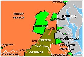
[citation needed] Around the year 1670, Seneca warriors from the New York Iroquois Confederacy conquered the territory of the Manahoac of Northern Piedmont.
The first treaties conducted at Albany between the two powers in 1674 and 1684 formally recognized the Iroquois claim to Virginia above the Fall Line, which they had conquered from the Siouan peoples.
The treaty reinforced the yearly tribute payments, and a 1680 annexe added the Siouan and Iroquoian tribes of Virginia to the roster of Tributary Indians.
From that time, the college was restricted to ethnic Europeans (or whites) until 1964, when the federal government passed civil rights legislation ending segregation in public facilities.
He envisioned having forts built along the frontier, which Tributary Nations would occupy, to act as buffers and go-betweens for trade with the tribes farther afield.
Spotswood worked to make peace with his Iroquois neighbours, winning a concession from them in 1718, of all the land they had conquered as far as the Blue Ridge Mountains and south of the Potomac.
This clause was to be a bone of contention decades later,[29] as it seemed to make the Blue Ridge the new demarcation between the Virginia Colony and Iroquois land.
The Cherokee border had to be readjusted in 1770 at the Treaty of Lochaber, because European settlement in Southwest Virginia had already moved past the 1768 Hard Labour line.
The Cherokee sold Richard Henderson a portion of their land encompassing extreme southwest Virginia in 1775 as part of the Transylvania purchase.
The chief led his Cherokee in a raid on Black's Fort on the Holston River (now Abingdon, Virginia) on July 22, 1776, launching the Cherokee–American wars of 1776–94.
In August 1780, having lost ground to the British army in South Carolina fighting, the Catawba Nation fled their reservation and temporarily hid in an unknown spot in Virginia.
They remained there in safety around nine months, until American general Nathanael Greene led them to South Carolina, after the British were pushed out of that region near the end of the revolution.
[31] In the summer of 1786, after the United States had gained independence from Great Britain, a Cherokee hunting party fought a pitched two-day battle with a Shawnee one at the headwaters of the Clinch River in present-day Wise County, Virginia.
[18] During this period, European Americans continued to push the Virginia Indians off the remaining reservations and sought to end their status as tribes.
[33] A holdover from the slavery years and Jim Crow, which still prevailed in the racially segregated state, the act prohibited marriage between whites and non-whites.
The Racial Integrity Act was not repealed until 1967, after the ruling of the US Supreme Court case Loving v. Virginia, which stated anti-miscegenation laws were unconstitutional.