Navigation
[1] In the European medieval period, navigation was considered part of the set of seven mechanical arts, none of which were used for long voyages across open ocean.
Early Pacific Polynesians used the motion of stars, weather, the position of certain wildlife species, or the size of waves to find the path from one island to another.
[citation needed] Maritime navigation using scientific instruments such as the mariner's astrolabe first occurred in the Mediterranean during the Middle Ages.
In 1498, a Portuguese expedition commanded by Vasco da Gama reached India by sailing around Africa, opening up direct trade with Asia.
[11][12][13] For about a hundred years, from about 1767 until about 1850,[14] mariners lacking a chronometer used the method of lunar distances to determine Greenwich time to find their longitude.
[18] Lines (or circles) of position can be derived from a variety of sources: There are some methods seldom used today such as "dipping a light" to calculate the geographic range from observer to lighthouse.
By knowing which point on the rotating Earth a celestial object is above and measuring its height above the observer's horizon, the navigator can determine his distance from that subpoint.
[25] In order to accurately measure longitude, the precise time of a sextant sighting (down to the second, if possible) must be recorded.
[25] A chronometer differs from a spring-driven watch principally in that it contains a variable lever device to maintain even pressure on the mainspring, and a special balance designed to compensate for temperature variations.
[25] A spring-driven chronometer is set approximately to Greenwich mean time (GMT) and is not reset until the instrument is overhauled and cleaned, usually at three-year intervals.
The frame is a rigid triangular structure with a pivot at the top and a graduated segment of a circle, referred to as the "arc", at the bottom.
As the index arm is moved, this mirror rotates, and the graduated scale on the arc indicates the measured angle ("altitude").
Light from the celestial body strikes the index mirror and is reflected to the silvered portion of the horizon glass, then back to the observer's eye through the telescope.
Before actually navigating, the initial latitude and longitude and the INS's physical orientation relative to the Earth (e.g., north and level) are established.
Space rated navigational computers, like those found on Apollo and later missions, are designed to be hardened against possible data corruption from radiation.
The signal is typically a simple AM broadcast of a morse code series of letters, which the RDF can tune in to see if the beacon is "on the air".
Most modern detectors can also tune in any commercial radio stations, which is particularly useful due to their high power and location near major cities.
It was approved for development in 1968 and promised a true worldwide oceanic coverage capability with only eight transmitters and the ability to achieve a four-mile (6 km) accuracy when fixing a position.
One, known as the "contour method," involves marking a transparent plastic template on the radar screen and moving it to the chart to fix a position.
A GNSS allow small electronic receivers to determine their location (longitude, latitude, and altitude) within a few meters using time signals transmitted along a line of sight by radio from satellites.
Since the first experimental satellite was launched in 1978, GPS has become an indispensable aid to navigation around the world, and an important tool for map-making and land surveying.
GPS also provides a precise time reference used in many applications including scientific study of earthquakes, and synchronization of telecommunications networks.
The cost of maintaining the system is approximately US$750 million per year,[39] including the replacement of aging satellites, and research and development.
The plan includes leaving the dock and harbor area, the en route portion of a voyage, approaching the destination, and mooring.
[20] Integrated systems take inputs from various ship sensors, electronically display positioning information, and provide control signals required to maintain a vessel on a preset course.
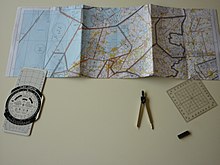
In land navigation, courses and training is often provided to young persons as part of general or extra-curricular education.
[53] Navigation is an essential everyday activity that involves a series of abilities that help humans and animals to locate, track, and follow paths in order to arrive at different destinations.
[58] It involves processes such as representation, planning and decision which help to avoid obstacles, to stay on course or to regulate pace when approaching particular objects.
[60] Also Barbara Tversky systematized the space, but this time taking into consideration the three dimensions that correspond to the axes of the human body and its extensions: above/below, front/back and left/right.
[60] Aided wayfinding requires a person to use various types of media, such as maps, GPS, directional signage, etc., in their navigation process which generally involves low spatial reasoning and is less cognitively demanding.