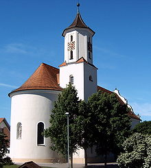
Neuler
[3] The municipality borders Rosenberg to the north, the town of Ellwangen to the northeast, Rainau to the east, Hüttlingen to the south, Abtsgmünd to the southwest, and Adelmannsfelden to the west.
The municipality of Neuler includes the village of Neuler, the hamlets of Bronnen, Ebnat, Gaishardt, Leinenfirst, Ramsenstrut and Schwenningen, the court Haldenhof, and the houses Adlersteige, Binderhof, Burghardsmühle, Burgstall, Himmelreich, Kohlwasen, Pfaffenhölzle and Schönberger Hof, as well as the deserted villages of Burgstall, Gern, Oberbrandhof, Schlierhof, Schliermühle, Schöffelhöfe and Schönenberg.
After World War II, Neuler belonged to the postwar state of Württemberg-Baden, founded in 1945 in the American occupation zone, from 1945 to 1952.
In the postwar years, the formerly agriculturally characterized town developed into a workers' residential community.
[6] The population figures from 1852 to 1970 are census results[7] and from 1980 onwards official updates from the Statistical State Office.

