New Jersey Route 29
Signed north-south, it runs 34.76 miles (55.94 km) from an interchange with Interstate 295 (I-295) in Hamilton Township in Mercer County, where the road continues east as I-195, northwest to Route 12 (Bridge Street / Race Street) in Frenchtown, Hunterdon County.
Between the southern terminus and I-295 in Ewing Township, the route is a mix of expressway and boulevard that runs along the Delaware River through Trenton.
This section includes a truck-restricted tunnel that was built along the river near historic houses and Riverview Cemetery.
Route 29 between South Warren Street in Trenton and I-95 (now I-295) in Ewing Township was upgraded to a four-lane expressway, with a portion of freeway, in the 1950s and 1960s.
Route 29 begins at a modified cloverleaf interchange with I-195 and I-295 in Hamilton Township, and it serves as the western continuation of I-195, heading to the northwest as a six-lane freeway.
[2][3] Route 29 runs along the bank of the Delaware River and enters a truck-restricted tunnel that passes by historic houses and Riverview Cemetery.
The median widens and it becomes a six-lane freeway, passing under the Morrisville–Trenton Railroad Bridge, which carries Amtrak's Northeast Corridor over the Delaware River.
Route 29 crosses the Assunpink Creek and features an interchange which provides access to South Warren Street with exits in both directions but only a northbound entrance.
[1] Route 29 becomes a four-lane boulevard at the intersection with Lee Avenue, where it continues northwest along the Delaware River.
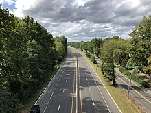
Farther north, Route 29 enters Hopewell Township and continues into a more rural setting shaded with trees.
[1][6] Route 29 continues north along the Delaware River through Titusville, passing by Washington Crossing State Park.
It comes to an interchange with US 202 just east of the New Hope–Lambertville Toll Bridge, with access to northbound US 202 and from southbound US 202 provided by way of Alexauken Creek Road.
Route 29 crosses back into Delaware Township, where it meets the southern terminus of CR 519 (Kingwood-Stockton Road).
The freeway's construction resulted in the filling of the canal, and also took up much of Trenton’s available waterfront along the Delaware River, destroying a Stacy Park, a major waterfront park, despite protests, which contributed to the population decline and economic impoverishment of Trenton over the ensuing decades.
[23] The roof was put in place in October 2001 and the tunnel officially opened to traffic on March 2, 2002.
[7] A part of Route 29 was designated in 1959 as the John Fitch Parkway, honoring inventor John Fitch, "beginning with the bridge crossing over the Assunpink Creek at the conjunction of Factory Street with John Fitch Way in the city of Trenton and including the traffic circle surrounding the War Memorial building and the freeway extending in a westerly direction therefrom, along the bank of the Delaware river, to the city line of the city of Trenton..."[27] During the 1960s the War Memorial and the surrounding circle were bypassed by a realignment of Route 29 closer to the Delaware River.
[28] In talks since the 1980s, the section of Route 29 in Trenton has been considered being redeveloped in order to connect city residents with the waterfront once again.
In July 2023, Trenton was granted $1.016 million from the Delaware Valley Regional Planning Commission to study proposals for redevelopment of the waterfront.
[29] The main plan is to turn Route 29 into an urban boulevard, as well as build a new mixed-used community adjacent to the waterfront, which includes a few new streets.
Additionally, the area around Riverview Plaza is supposed to receive pedestrian and cycling improvements as a part of the new Delaware River Heritage Trail.