New Madrid, Missouri
[4] The city is located 42 miles (68 km) southwest of Cairo, Illinois, and north of an exclave of Fulton County, Kentucky, across the Mississippi River.
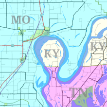
Scientists expect the river eventually to cut across the neck of the peninsula and make a more direct channel, leaving the Kentucky territory as an island.
The first more or less permanent settlement at present-day New Madrid was established by bands of Shawnee, Delaware, Creek, and Cherokee who were turned into refugees due to the U.S. War for Independence.
These refugee Native American bands accepted Spanish offers to settle on the west bank of the Mississippi River in the early 1780s.
These mixed Native American groups established a settlement and informal trading post where a northward, horseshoe bend of the Mississippi met the Chepusa creek, which provided an easy place for landing boats.
Native American hunters and European-American merchants made the settlement a location for processing the bounty of hunts, including the valuable but messy fat of bears and buffalo, which was used in preparing skins and furs.
The settlement quickly acquired the name L’Anse a la Graise — “Cove of Grease” or “Greasy Cove.” European Americans renamed the settlement New Madrid around 1780 under the auspices of Spanish Governor Bernardo de Gálvez, who was appointed to rule Spanish Louisiana (the land west of the Mississippi River),[5] and Manuel Pérez, Lieutenant Governor of Upper Louisiana in Saint Louis.
[6] They welcomed settlers from the United States, but required them to become subjects of (i.e. swear allegiance to) the Spanish crown.
In addition, they had to agree to live under the guidance of his appointed empresario, Colonel George Morgan, an American Revolutionary War veteran from New Jersey.
Morgan recruited a number of American families to settle at New Madrid, attracting a few hundred people to the region.
Surrounded by low, swampy land, New Madrid developed a well-earned reputation for diseases, especially in the summer and fall.
After trying to regain control of Saint-Domingue (the present Haiti), where a slave rebellion was underway, Napoleon gave up on his North American colonies, agreeing to sell this territory to the United States in 1803 as part of the Louisiana Purchase.
[8] Starting in 1838, New Madrid was on the Trail of Tears that saw thousands of Indians forcefully removed from Eastern lands and moving to Oklahoma.
[9] During the Civil War, the Battle of Island Number Ten took place on the Mississippi River near New Madrid.
In the antebellum period, this fertile floodplain area was developed for cotton plantations, based on the labor of enslaved African Americans.
As whites struggled to re-establish dominance after the Reconstruction era, they intimidated and attacked blacks under the guise of Jim Crow laws, working to suppress voting and control their activities.
Three African-American men are documented as being lynched by whites in New Madrid, the county seat, near the turn of the century: Unknown Negro, on November 29, 1898; Louis Wright, a musician in a minstrel show accused of altercations with whites, hanged on February 17, 1902;[10] and unknown Negro, May 30, 1910.
Rainfall is fairly heavy throughout the year due to moist air from the Gulf being advected on the western side of the Bermuda High, plus occasional remnant depressions from hurricanes passing up the Mississippi Valley.
Sulfur dioxide pollution in the Bootheel has been found to exceed National Ambient Air Quality Standards.
Philip Raidt, who was born in Württemberg, Germany in 1825, helped to organize the first free school in New Madrid County.