New York – New Jersey Line War
Governor Nicolls immediately realized that the charter meant the loss of valuable land from the New York colony, and was compelled to write the Duke to tell him that the land comprising New Jersey, as delineated in the charter, comprehended all the improveable part of Your Royal Highness his Pattent and capable to receive twenty times more people than Long Island and all the remaining Tracts in Your Royal Highness his patent in respect not onely to the quantity of the Land but to the Coast of Delaware River the fertility of the soyle the neighborhood to Hudsons River, and lastly the faire hopes of Rich mines, to the utter discouragement of any that shall desire to live under your Royal Highness his protection.Governor Nicolls believed that the magnitude of the loss was so great that it could have only resulted from a conspiracy against the fortune of the Duke, and he continued his letter by stating, Neither can I suppose that My Lord Berkeley or Sir G. Carterett know how prejudiciall such a graunt would prove to Your Royal Highness, but I must charge it upon Capt.
The confusion created by this revelation would be capitalized on by New York in order to stall any attempts at establishing the border's exact location and, thus, the legitimacy and stability so necessary for a healthy business environment in the new colony of New Jersey.
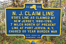
Some may argue that the dispute continued until 1896, when a joint state commission completed an accurate survey that compensated for measurement distortions caused by local iron ore formations, but for the purposes of this paper, we will follow the dispute—including its complicated political and economic battles and small skirmishes between residents of both states—until the compromise of 1769.
This agreement divided the colony of New Jersey into East and West sections, with the partition line stretching "from the eastside of Little Egg Harbor, straight north, through the country, to the utmost branch of Delaware River.
Pasting together a rough picture, it seems as though Governors Thomas Dongan of New York and Gawen Lawrie of New Jersey, along with their respective councils, met near Tappan on the Hudson River.
They agreed to establish the east station point of the border at the mouth of Tappan Creek, and assured each other that surveyors would soon be hired to run the final line to the Delaware River.
[8] A discussion of this Tappan meeting is found in the minutes of the Council of New York for April 9, 1684, which instructed the Indians to observe the surveyors while they placed markers on the Delaware, and to sell only to New Yorkers land to the north of that line.
I Do hereby Certify that some Time in or about as I Believe the year 1685, or 1686, Col. Thomas Dongan then Governor of New York and others met with Gawen Lawry, then Governor of New Jersey with some of the Gentlemen of the Council of New Jersey and others at a Place nigh which stood afterwards the house of Col. William Merrett on the West Side of Husdsons River where an observation was then made of the latitude and mark'd with a Pen Knife on a Beech-Tree standing by a small Run or Spring of Water that Run down the North Side of the Place where I think Merrett's House afterwards stood.
The Council of New York instructed Wells: You are carefully and with great exactness to run the Line between this province and that of East Jersey, beginning in the latitude of forty-one degrees and forty minutes upon the Delaware River.
It was even claimed that Governor Dongan had all New York grants predate New Jersey's by one day, so they could be used as evidence in any later property and border disputes.
These governmental actions along the border region created a great deal of insecurity among settlers and holders of land grants, and may have resulted in uncommon settlement patterns near Tappan Creek.
[15] The first settlement along the western border region began in 1690 with the founding of the town of Port Jervis on the Delaware River by the Cortright, Van Auken, Westbrook, Decker, Kuykendal, Westfall, Titsworth, Cole, and Davis families.
Governor Hamilton asked that a joint effort between the colonies be undertaken to exactly survey the line, so that taxes could be assessed correctly, and militia training begun.
[17] The East New Jersey Board of Proprietors, frustrated by inaction after repeated complaints to New York, voted on May 5, 1695, to complete the necessary border survey on their own.
In 1705, Peter Fauconnier, a Collector and Receiver General in New Jersey, reported to Lord Cornbury that those living along the border were, "neither here nor there"[30] in relation to their residency.
Hunter explained that his goal was "to prevent future Disputes and Disquiet and to do Justice to the Proprietors on the Borders of both a like law for that purpose is the necessary Line.
[37]This charge was far more specific than New Jersey's and left Allane Jarrat in the limited position of having to place the northern station point at 41°40′, and not at the location of the northernmost branch of the entire Delaware River.
Jarrard wholly declined the same alleging that he could not undergo the fateaque thereof (altho' what he had experienced was very small to what I apprehended the event would be)[38]Even with Jarrat's lack of cooperation, the final camp was reached on July 8, at a location on the Delaware 35 miles (56 km) north of the "Mahakkamack" branch.
Reading's Journal reports: in the morning the surveyors disagreed concerning the use of tables for calculating the suns and stars place and if that they had not been there they had certainly left the station unfixed, which after a great many arguments they agreed to settle, a memorandum of which was taken and brought down.
The "Tri Partite Deed" was signed two days later on July 27, 1719, along the Hudson River, after surveys placed the eastern station point 5 miles (8.0 km) north of Tappan Creek (figure 2).
Allane Jarrat, in early September 1719, informed the Council of New York that the surveying instruments used on the expedition were actually inaccurate, and that his conscience would not allow him to accept the "Tri Partite Deed".
According to the petition, Jarrat felt unwilling "to relye on my own judgement in so weighty and affair that so highly concerns the care of this province for Taphan and sundry other Gentlemens estates."
This second petition, supported Jarrat's contentions, reminded the Council of the 1694 agreement between Governors Hamilton and Fletcher (placing the east station point at Tappan Creek), accused Captain Harrison of lying when he reported there were no other branches farther north on the Delaware, and requested that the final survey be held up until the King decided on the legitimacy of the 1717 debt bill.
The coincidence of these petitions arriving on the same day, clearly indicates that these important gentlemen, alarmed that they could lose property rights to land that was theirs as long as a disputed boundary line was placed farther south, must have convinced Jarrat to back out of an already signed agreement with the other commissioners.
With Governor Hunter in London, Peter Schuyler, along with other powerful New York leaders, was able to take control of the situation, and swing matters in his favor.
The concerns of these New York gentlemen were fueled by their increasing awareness that the disputed border lands were rich in iron ore, water power, and charcoal yielding forests.
"[54] In response to New York's actions, the East New Jersey Board of Proprietors, on September 29, 1719, wrote to Robert Morris about their concern that the effort to finally establish the disputed border could be stopped: upon the groundless, weak, and untrue suggestions of the petitioners, and the visionary whim and cant of the surveyor; after the same had been directed to be done by the legislature of both Provinces, and commissioners had been appointed under the Great Seal of each of than that purpose; and had made (at a very great expense) so considerable profit.
Below is a summary of some of these positions: This letter ended by suggesting that an investigation be begun immediately to examine the entire case and to report the results to the Board as soon as was possible.
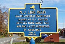
By 1720, Thomas and Jacobus Swartwout of New York and John and Nicholas Westphalia of New Jersey were alternately burning each other's crops, claiming the others did not have proper title to their lands.
Every legal impediment was brought to bear, and the entire dispute was eventually thrown into the hands of the Board of Trade in London where it would sit for years.