Niger River
[citation needed] Nevertheless, "Nigris" was already the name of a river in West Africa, as mentioned by Pliny the Elder and Solinus, among others.
[18] As Timbuktu was the southern end of the principal Trans-Saharan trade route to the western Mediterranean, it was the source of most European knowledge of the region.
[16] When European colonial powers began to send ships along the west coast of Africa in the 16th and 17th centuries, the Senegal River was often postulated to be the seaward end of the Niger.
The Niger Delta, pouring into the Atlantic through mangrove swamps and thousands of distributaries along more than 160 kilometres (100 mi), was thought to be coastal wetlands.
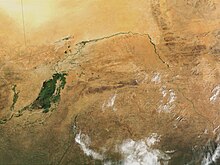
[20] The result is a region of braided streams, marshes, and large lakes; the seasonal floods make the Delta extremely productive for both fishing and agriculture.
[3] The Niger takes one of the most unusual routes of any major river, a boomerang shape that baffled geographers for two centuries.
Its source (Tembakounda) is 240 km (150 mi) inland from the Atlantic Ocean, but the river runs directly away from the sea into the Sahara Desert, then takes a sharp right turn near the ancient city of Timbuktu and heads southeast to the Gulf of Guinea.
This made it the focal point of trade across the western Sahara and the centre of the Sahelian kingdoms of Mali and Gao.
The Niger River basin, located in western Africa, covers 7.5% of the continent and spreads over ten countries.
[31] Like in the Fertile Crescent, many food crops were domesticated in the Niger River region, including yams, African rice (Oryza glaberrima), and pearl millet.
[30] Agriculture, as well as fishing and animal husbandry, led to the rise of settlements like Djenné-Djenno in the Inner Delta, now a World Heritage Site.
Much of the northern Niger basin remains Muslim today, although the southern reaches of the river tend to be Christian.
Classical writings on the interior of the Sahara begin with Ptolemy, who mentions two rivers in the desert: the "Gir" (Γειρ)[34][35] and farther south, the "Nigir" (Νιγειρ).
[41] Through the descriptions of Leo Africanus and even Ibn Battuta – despite his visit to the river – the myth connecting the Niger to the Nile persisted.
They carried a 16mm movie camera, the resulting footage giving Rouch his first two ethnographic documentaries: "Au pays des mages noirs", and "La chasse à l’hippopotame".
The construction of dams for hydropower generation is underway or envisaged in order to alleviate chronic power shortages in the countries of the Niger basin.