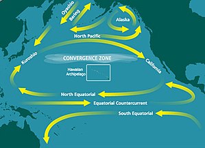
North Pacific Gyre
It is the largest ecosystem on Earth, located between the equator and 50° N latitude, and comprising 20 million square kilometers.
It is the site of an unusually intense collection of human-created marine debris, known as the Great Pacific Garbage Patch.
The westward flow within the elongated tropical cyclonic circulation is also included in the North Equatorial current.
In the western region of the North Pacific, the surface of the Subtropical Gyre generally has a "C-shape".
From here the "C-shape" then flows eastward comprising the Subtropical Countercurrent at roughly 20–25°N, then finally the "C" wraps back towards the west forming the North Equatorial Current just south of 20°N.
The Subtropical Countercurrent is a shallow area of this "C"; at only about 250 dbar under the surface, circulation is a simpler closed, anticyclonic gyre.
[2] With increasing depth in the North Pacific Subtropical Gyre, it gets smaller in the western region near Japan and it also loses strength.
The Subtropical Gyre does not exist below 1500 m below the surface with the exception of the Kuroshio Current and Extension regions.
[10] Despite the common public perception of the patch existing as giant islands of floating garbage, its low density (4 particles per cubic metre (3.1/cu yd)) prevents detection by satellite imagery, or even by casual boaters or divers in the area.
This is because the patch is a widely dispersed area consisting primarily of suspended "fingernail-sized or smaller"—often microscopic—particles in the upper water column known as microplastics.