North Saskatchewan River valley parks system
In 1996, the River Valley Alliance (RVA) was formed to coordinate the development of the park system across the metropolitan region.
[3] The introduction of non-native vegetation may be attributed to the arrival of Métis and European farmers; who also harvested trees for lumber, and used the valley as a grazing area for their livestock.
[3] Industrial developments in the river valley occurred during the late 19th and early 20th century, after the establishment of Fort Edmonton.
[5] During the mid-20th century, proposals to use the river valley for a highway network were submitted, with work on the freeway beginning at MacKinnon Ravine Park.
[4] In 1907, landscape architect Frederick Todd proposed that the city should take advantage of the natural space provided by the river valley.
[4] In 1915, the provincial government adopted a report by Todd to protect the river valley and its associated ravines as a recreational area.
[6] In 1933, the City of Edmonton passed a local bylaw to regulate land use and to preserve the river valley as parkland.
[4] During this period, small pieces of land were acquired to complete the trail system planned by the municipal and provincial government; connecting Hermitage Park and the High Level Bridge.
[4] In 1976, the provincial government also issued Orders-in-Council to restrict developments around the river valley from Devon to Fort Saskatchewan.
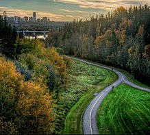
[7][8] A plan to unite the various parks that surrounded the North Saskatchewan River in the Edmonton Metropolitan Region was conceived during the early 1990s.
[25] Several hectares of private land were also acquired by the municipal government in 2008 in order to "bridge the gaps" between the river valley's trail system.
[34] As of 2020, the RVA continues to pursue the acquisition of private land around the river valley in order to fulfill the vision of an uninterrupted, connected trail system.
[25] Private facilities located in the river valley include EPCOR Utilities' Gold Bar Wastewater Treatment Plant.
[35] Additionally there exist several thousand properties and residential homes that are situated within 50 metres (160 ft) of the river valley.
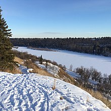
In addition to its recreational uses, the river valley is also used to provide a number of ecological services, including carbon sequestration, erosion control, and stormwater management.
[40] During this period a number of non-native fruit and vegetable species, shrubs, and trees were introduced into the river system.
[45] Animals commonly found in the river valley includes coyotes, great horned owls, lake sturgeons, North American porcupines, pileated woodpeckers, plains garter snakes, walleye, and white-tailed deer.