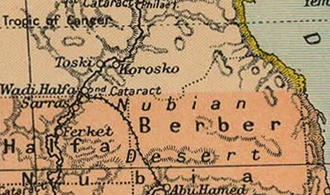
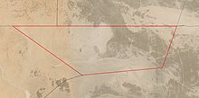
Bir Tawil
'tall water well', [biːɾ tˤɑˈwiːl]) is a 2,060 km2 (795.4 sq mi) area of land along the border between Egypt and Sudan, which is uninhabited and claimed by neither country.
[2] On 19 January 1899, an agreement between the United Kingdom and Egypt relating to the administration of Sudan defined "Soudan" as the "territories south of the 22nd parallel of latitude".
[3] On 4 November 1902, the UK drew a separate "administrative boundary", intended to reflect the actual use of the land by the tribes in the region.
[3] Bir Tawil was grazing land used by the Ababda tribe based near Aswan, and thus was placed under Egyptian administration from Cairo.
In the east is Gabal Hagar El Zarqa, with a height of 662 metres (2,172 ft), marking the territory's highest point.
[9][10]Bir Tawil has no settled population, but members of the Ababda and Bishari tribes pass through the region,[9] and unregulated mining camps have been established throughout the territory in search of gold deposits.