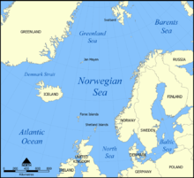
Coastline of Norway
A straight line along Norway's sea borders (the coastal perimeter) is 2,650 kilometers (1,650 mi) long.
[1][2] Along the coast there are many fjords, islands, and bays, resulting in a low-resolution coastline of over 25,000 kilometers (16,000 mi).
[3] At 30-meter (98 ft) linear intercepts, this length increases to 83,281 kilometers (51,748 mi)[4] (see the coastline paradox).
There are only a few shorter or longer stretches where the mainland is exposed to the open sea along the coast: at Lindesnes, Lista, Jæren, Stad, Hustadvika, and Folda in Trøndelag, and along the Varanger Peninsula.
Because of countless peninsulas and inlets, large and small islands, holms, and skerries, the Norwegian coast is among the longest in the world.