Norwood, Ohio
Originally settled as an early suburb of Cincinnati in the wooded countryside north of the city, the area is characterized by older homes and tree-lined streets.
The Adena constructed the mound at the location of Norwood's present-day Water Tower Park, which is the highest land elevation in the city.
Archaeologists believe the mound was built at this site due to the high elevation and was used by the Adena for religious ceremonies and smoke signaling.
Native American mounds are not uncommon in Ohio and several were located in Downtown Cincinnati at the time of arrival of the first white settlers.
[10] In the early-20th century, Norwood High School named their sports team mascot the Indians in honor of this local Native American heritage.
In 1793, General "Mad Anthony" Wayne led several companies of troops from Fort Washington in Cincinnati to advance against a hostile tribe of Native Americans encamped on the banks of the nearby Millcreek in what is now St. Bernard.
The tracks ran from east to west through Sharpsburg and still exist in the same location today, parallel to the Norwood Lateral Expressway and passing under the Montgomery Road overpass.
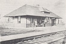
The village did not initially have a train station when the railway opened, but the possibility of passenger rail access to Cincinnati generated interest in developing a residential subdivision nearby.
In 1869, Sylvester H. Parvin, Col. Philander P. Lane and Lemuel Bolles purchased the William Ferguson farm north of the Marietta and Cincinnati Railroad tracks and platted an eighty-one-acre subdivision they called Norwood Heights.
[18] Despite the initial interest in Norwood generated by the arrival of the Marietta and Cincinnati Railroad, the new subdivisions were premature and failed to immediately take off.
Around the same time, construction was started on another railroad, the Cincinnati and Eastern Railway, which was built west to east along the present-day border of Norwood and Evanston.
The tracks continued along Wasson Road in Hyde Park, connecting Norwood with Cincinnati's eastern suburbs and ultimately Portsmouth, Ohio.
[15] The arrival of the passenger railroad proved to be the catalyst for rapid population growth in Norwood, as Cincinnatians could now work downtown and commute to their homes in the suburbs.
Later that year, the Andrew Carnegie Foundation provided funds to begin construction of Norwood's first public library, which opened in 1907.
[28] In 1908, Greek immigrants, Thomas and Nicholas Aglamesis, opened an ice cream parlor on Montgomery Road in Norwood.
The Norwood store eventually closed, but their Oakley location, known as Aglamesis Bro's, remains a popular Cincinnati institution to this day.
[33] Albers, the former president of the Kroger Company, went on to revolutionize the grocery industry by embracing many innovations such as shopping carts, fluorescent lighting, and individual pricing on all items.
This was one of the first significant steps in the transformation of Norwood's downtown business district, known as "The Pike," from pedestrian-friendly storefronts to the Surrey Square automobile-centric strip mall.
To accommodate the extension, nearly 200 homes in the old East Norwood neighborhood were razed, resulting in a loss of population and property tax revenue.
[41] After the Albers Supermarket was destroyed by fire in 1968, Norwood purchased the property and demolished the building as part of an urban renewal plan.
[43] On November 6, 1986, General Motors announced that it would close the Norwood Assembly automobile plant as part of a $10 billion plan to reorganize the company.
GM was by far the largest employer in Norwood and its income and property taxes accounted for one-third of the city's operating budget and one-fifth of the money for its schools.
The same year, the city also made plans to build a retail and restaurant complex called Rookwood Pavilion on the site of the old LeBlond plant.
[44] In July 1990, a cleaning solvent leak at the BASF chemical plant on the border of Norwood and Evanston resulted in an explosion, killing two and injuring 90 people.
[47] Norwood also lost a significant amount of public transportation in 2004 when the Southwest Ohio Regional Transit Authority eliminated all but two bus routes in the city.
In 2006, developers broke ground on Linden Pointe on the Lateral, a large office park complex on the old former American Laundry Machine Company and Globe Wernicke properties.
Xavier University acquired the old Norwood Plaza shopping center and demolished many of the structures to make way for campus expansion.
As the city is ideally situated between several major railways, state roads and interstate highways, it has traditionally been an attractive location for businesses and corporations in the area.
[60] The current high school opened as a state-of-the-art facility in 1972, with a planetarium, greenhouse, swimming pool, and television studio.
In 1988, the Norwood Middle School field house and offices were used to film prison scenes in the 1989 Tom Selleck movie An Innocent Man.