Nyabarongo River
From its start, Nyabarongo flows northward for 85 km (53 miles), and forms the border between the Western and Southern Provinces.
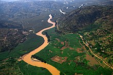
[1] The river's sources rise in the mountain chain that covers most of the western third of Rwanda, to the east of the Albertine Rift.
[2] The main headwaters in the forested mountain country, originating at heights of 2,600 to 2,750 metres (8,530 to 9,020 ft) above sea level, are the Mbirurume and Mwogo rivers.
[5] The Nyawarungu runs northward through the mountain chain in a deep valley roughly parallel to Lake Kivu and about the same elevation of about 1,500 metres (4,900 ft).
From there onward it is called the Kagera River, the main affluent of Lake Victoria, which drains into the Nile.
[7] The lakes on the right bank, from north to south, are Gashanga, Kidogo, Rumira, Maravi, Kilimbi, Gaharwa, Rweru and Kanzigiri.
[8] Lake Rweru, which mostly lies in Burundi, drains in a northeast direction into the river through a short swampy section.
Further down, common plants are Ficus verruculosa, Myrica kandtiana, Phoenix reclinata and Cyperus papyrus.
It is of great importance for biodiversity conservation, especially birds, with species such as the endangered Malagasy pond heron (Ardeola idae), the near-threatened papyrus gonolek (Laniarius mufumbiri), the vulnerable grey crowned crane (Balearica regulorum), and the sitatunga (Tragelaphus spekii).