Ocean gyre
In oceanography, a gyre (/ˈdʒaɪər/) is any large system of ocean surface currents moving in a circular fashion driven by wind movements.
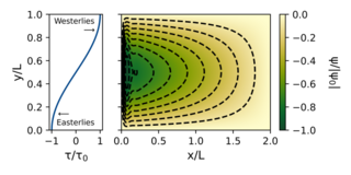
The largest ocean gyres are wind-driven, meaning that their locations and dynamics are controlled by the prevailing global wind patterns: easterlies at the tropics and westerlies at the midlatitudes.
[3] Ekman suction results in a depressed sea surface height and cyclonic geostrophic currents in subpolar gyres.
[9] Contributions by both Henry Stommel and Walter Munk resolved this issue by showing that the return flow of gyres is done through an intensified western boundary current.
The South Equatorial Current forms the northern boundary of the Indian Ocean Gyre as it flows west along the equator towards the east coast of Africa.
The wind stress curl in this region drives the Ekman suction, which creates an upwelling of nutrient-rich water from the lower depths.
[26] The Atlantic Meridional Overturning Circulation (AMOC) is a key component of the global climate system through its transport of heat and freshwater.
[26] The North Atlantic Subpolar Gyre is in a region where the AMOC is actively developed and shaped through mixing and water mass transformation.
It is a region where large amounts of heat transported northward by the ocean are released into the atmosphere, thereby modifying the climate of northwest Europe.
[27] The North Atlantic Subpolar Gyre has a complex topography with a series of basins in which the large-scale circulation is characterized by cyclonic boundary currents and interior recirculation.
There are several branches of the North Atlantic Current, and they flow into an eastern intergyral region in the Bay of Biscay, the Rockall Trough, the Iceland Basin, and the Irminger Sea.
The gyre plays a crucial role in the transport of heat, nutrients, and marine life in the Southern Ocean, affecting the distribution of sea ice and influencing regional climate patterns.
The relative reduction of sea surface heights to the north facilitates a northeastward expansion of the outer boundary of the Ross Gyre.
The ensuing southward Ekman transport anomaly raises sea surface heights over the continental shelf and accelerates the westward throughflow by increasing the cross-slope pressure gradient.
The sea level pressure center may have a greater impact on the Ross Gyre transport or the throughflow, depending on its location and strength.
Insights into the behavior and variability of the Weddell Gyre are crucial for comprehending the interaction between ocean processes in the southern hemisphere and their implications for the global climate system.
[33] The anti-cyclonic Beaufort Gyre is the dominant circulation of the Canada Basin and the largest freshwater reservoir in the Arctic Ocean's western and northern sectors.
This gyre functions as a critical mechanism for the transport of heat, nutrients, and sea ice within the Arctic region, thus influencing the physical and biological characteristics of the marine environment.
Negative wind stress curl over the region, mediated by the sea ice pack, leads to Ekman pumping, downwelling of isopycnal surfaces, and storage of ~20,000 km3 of freshwater in the upper few hundred meters of the ocean.
The strong atmospheric circulation in the autumn, combined with significant areas of open water, demonstrates the effect that wind stress has directly on the surface geostrophic currents.
[36] The Beaufort Gyre and the Transpolar Drift are interconnected due to their relationship in their role in transporting sea ice across the Arctic Ocean.
[44] A commonly accepted method for relating different nutrient availabilities to each other in order to describe chemical processes is the Redfield, Ketchum, and Richards (RKR) equation.
[45] Lack of nutrients in the surface waters of subtropical gyres is related to the strong downwelling and sinking of particles that occurs in these areas as mentioned earlier.
[50][51] Iron limitation in high-nutrient, low-chlorophyll regions results in water that is rich in other nutrients because they have not been removed by the small populations of plankton that live there.
The photosynthesis of phytoplankton communities in this area seasonally depletes surface waters of carbon dioxide, removing it through primary production.
[54] Generally, spring is an important time for photosynthesis as the light limitation imposed during winter is lifted and there are high levels of nutrients available.
The United Nations Declaration on the Rights of Indigenous Peoples begins by reminding readers that “respect for Indigenous knowledge, cultures and traditional practices contributes to sustainable and equitable development and proper management of the environment”[56] Attempts to collect and store this knowledge have been made over the past twenty years.
[67][68] A garbage patch is a gyre of marine debris particles caused by the effects of ocean currents and increasing plastic pollution by human populations.
These human-caused collections of plastic and other debris are responsible for ecosystem and environmental problems that affect marine life, contaminate oceans with toxic chemicals, and contribute to greenhouse gas emissions.
[70] The 10 largest emitters of oceanic plastic pollution worldwide are, from the most to the least, China, Indonesia, Philippines, Vietnam, Sri Lanka, Thailand, Egypt, Malaysia, Nigeria, and Bangladesh,[71] largely through the rivers Yangtze, Indus, Yellow, Hai, Nile, Ganges, Pearl, Amur, Niger, and the Mekong, and accounting for "90 percent of all the plastic that reaches the world's oceans".