Ojos del Salado
The complex extends over an area of 70–160 square kilometres (27–62 sq mi) and its highest summit reaches an altitude of 6,893 metres (22,615 ft) above sea level.
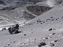
Being close to the Arid Diagonal of South America, the mountain has extremely dry conditions, which prevent the formation of substantial glaciers and a permanent snow cover.
Ojos del Salado can be ascended from both countries; the first ascent was made in 1937 by Jan Alfred Szczepański and Justyn Wojsznis [pl], members of a Polish expedition in the Andes.
[21] The massif appears to feature a buried caldera,[20] visible through a slope break from the western side,[33] and/or a 2.5-kilometre-wide (1.6 mi) depression.
[36] Cerro Solo and El Fraile are large lava domes on the flanks of Ojos del Salado,[32] and produced pyroclastic flows.
[65] Except for firn and small glaciers in sheltered parts of the mountain, Ojos del Salado lacks substantial ice cover.
This is due to the arid climate of the region, which causes the equilibrium line altitude of ice to rise above the top of the mountain[39] and keeps most peaks in the area ice-free.
[79] Cryokarst,[80] erosional gullies and so-called "infilled valleys"[i] have been observed; they most likely form when buried ice and snow melt.
[82] The combined effect of erosion by the meltwater and the disappearance of ice volume creates cavities that collapse and form the valleys and pseudokarst landforms.
[83] Lateral moraines altered by wind erosion occur north of Ojos del Salado[43] and some lava flows bear traces of glaciation.
[93][j] The CVZ spans Peru, Bolivia, Chile and Argentina and contains about 1,100 recognized volcanoes, many of which are extremely old and are still recognizable owing to the low erosion rates in the region.
[103][93] The basement in the region crops out in the Cordillera Claudio Gay area, and consists of sedimentary rocks of Devonian[l]-Carboniferous[m] age.
[105] Volcanism in the region commenced 26 million years ago, when the Farallon Plate broke up and subduction speed increased.
This shift coincided with a gradual flattening of the subduction process since the Miocene[o] and was accompanied by change in crustal and mantle properties that are reflected in the isotope ratios of erupted volcanic rocks.
[30] Argentine geological maps define a "Ojos del Salado basal complex", which consists of a number of Miocene volcanoes that have erupted andesite and dacite, partially in glacial environments.
[113][114][31] A pyroclastic flow erupted by Ojos del Salado descended the Cazadero valley and constitutes the "El Quemado Ignimbrite".
[115] Cerro Solo, whose emplacement was probably accompanied by intense pyroclastic flow activity,[116] and lava domes in the summit region are of Pleistocene age.
[91] The volcano produced lava flows during the Holocene,[20] which cover an area of 120 square kilometres (46 sq mi), as well as pumice deposits at Laguna Verde and elongated fractures in the summit region.
[34] A rhyodacitic eruption[17] was dated with tephrochronology to have occurred 750 ± 250 CE,[121] and may have deposited tephra over the Bolson de Fiambala and in the Tafí and Villa Vil areas of northwestern Argentina.
[136] Hot springs occur at the shores of Laguna Verde[137] which may be part of a hydrothermal circulation system of Ojos del Salado.
[46] Salt, acid and cold-tolerant bacteria have been recovered from sediments in the lakes on Ojos del Salado, consistent with microorganism samples from similar dry volcanic environments.
[151] Birds such as ducks, flamingos and geese and mammals such as guanacos and vicuñas occur in the Santa Rosa-Maricunga-Negro Francisco region.
[156][5] The Inca used the Paso San Francisco as a major crossing of the Andes[157] but there is no evidence of them building any structures on Ojos del Salado[q][160] even though a number of such sites exist in the surrounding region.
[5][r] Ojos del Salado is likewise absent from the 1861 plans of William Wheelwright for a railway across Paso San Francisco.
[167] These measurements set off a debate whether Ojos del Salado was higher than Aconcagua and thus the highest summit of the Western Hemisphere,[168] and drew attention to the mountain.
[170] The debate on the elevation and confusion about which mountain was Ojos del Salado and who climbed which peak prompted an expedition by the American Alpine Club in 1956.
[169] The expedition was hindered by bad weather conditions[171] and a gust of wind stretching a measurement line may have almost frustrated the goal to determine the summit elevation of Ojos del Salado.
[174] In 1989, Francesco Santon of the University of Padua in Italy, with Argentine assistance, used GPS-based positioning to determine an elevation of 6,900 ± 5 metres (22,638 ± 16 ft).
[184] From Argentina, the path runs from Cazadero Grande (Quemadito hut) along a large creek to its origin at Aguas Calientes at 4,200 metres (13,800 ft).
[188] As of 2020[update], the establishment of a "zone of touristic interest" encompassing Ojos del Salado was under discussion in Chile.