Cascade Range
[4] The range is near the Pacific Ocean and in the region's prevailing westerly winds, so it receives significant rain and snowfall, especially on the western slopes due to orographic lift, with annual snow accumulations of up to 1,000 inches (2,500 cm) (= 83 feet (25 m)) in some areas.
It is not uncommon for some places in the Cascades to have over 500 inches (1,300 cm) of annual snow accumulation, such as at Lake Helen, near Lassen Peak.
[12] Beyond the eastern foothills is an arid plateau that was largely formed 17 to 14 million years ago by the many flows of the Columbia River Basalt Group.
Together, these sequences of fluid volcanic rock form the 200,000-square-mile (520,000 km2) Columbia Plateau in eastern Washington, Oregon, and parts of western Idaho.
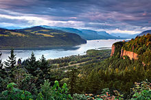
As the range grew, erosion from the Columbia River was able to keep pace, carving out the gorge and major pass seen today.
[18] In early 1792, British navigator George Vancouver explored Puget Sound and gave English names to the high mountains he saw.
[21] On their return trip, Lewis and Clark spotted a high but distant snowy pinnacle that they named for the sponsor of the expedition, U.S. President Thomas Jefferson.
[24][25] In 1814, Alexander Ross, a fur trader with the North West Company, seeking a viable route across the mountains, explored and crossed the northern Cascades between Fort Okanogan and Puget Sound.
Due to the difficulty of crossing the northern Cascades and the paucity of beaver, fur-trading companies made only a few explorations into the mountains north of the Columbia River after Ross.
[26] Exploration and settlement of the Cascades region by Europeans and Americans was accelerated by the establishment of a major trading post of the Hudson's Bay Company (HBC) at Fort Vancouver near today's Portland, Oregon.
[27] The course of political history in the Pacific Northwest saw the spine of the Cascade Range being proposed as a boundary settlement during the Oregon Dispute of 1846.
Much of the northern half of the Cascades, from Rainier north, have been preserved by U.S. national or British Columbia provincial parks (such as E.C.
[29] The Canadian side of the range has a history that includes the Fraser Canyon Gold Rush of 1858–60 and its famous Cariboo Road, as well as the older Hudson's Bay Company Brigade Trail from the Canyon to the Interior, the Dewdney Trail, and older routes which connected east to the Similkameen and Okanagan valleys.
Near Hope, B.C., the railway roadbed and the Othello Tunnels, now decommissioned, are popular tourist recreation destinations for hiking and bicycling.
The pass is used by the Coquihalla Highway, a government megaproject built as part of the Expo 86 spending boom of the 1980s, which is now the main route from the Coast to the British Columbia interior.
Traffic formerly went via the Fraser Canyon, to the west, or via Allison Pass and Manning Park along Highway 3 to the south, near the border.
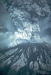
[30] The Cascade Range is made up of a band of thousands of very small, short-lived volcanoes that have built a platform of lava and volcanic debris.
[32] As the oceanic slab sinks deep into the Earth's interior beneath the continental plate, high temperatures and pressures allow water molecules locked in the minerals of solid rock to escape.
Much of their meltwater eventually flows into reservoirs, where it is used for recreation, while its potential energy is captured to generate hydroelectric power before the water is used to irrigate crops.
One of these, Ross Dam on the Skagit River, retains a reservoir which spans the border southeast of Hope, British Columbia, extending 2 miles (3.2 km) into Canada.
[33] The highest recorded underground temperature found in the range is 510 °F (266 °C) at 3,075 feet (937 m) below Newberry Volcano's caldera floor.
Cool, wet winters and warm, dry summers (largely a result of oceanic influence) favor evergreen species, whereas mild temperatures and rich soils promote fast and prolonged growth.
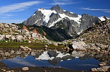
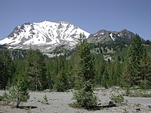
[36] Most of the Cascades' lower and middle elevations are covered in coniferous forest; the higher altitudes have extensive meadows as well as alpine tundra and glaciers.
[37] Black bears, coyotes, bobcats, cougars, beavers, deer, elk, moose, mountain goats and a few wolf packs returning from Canada live in the Cascades.