Orienteering map
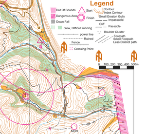
In addition to indicating the topography of the terrain with contour lines, orienteering maps also show forest density, water features, clearings, trails and roads, earthen banks and rock walls, ditches, wells and pits, fences and power lines, buildings, boulders, and other features of the terrain.
[2] A map that is reliable and accurate is essential so that a course can be provided which will test the navigational skills of the competitor.
Because the competition must test the navigational skills of the competitor, areas are sought which have a terrain that is rich in usable features.
Orienteering maps are expensive to produce and the principal costs are: the fieldwork, drawing (cartography), and printing.
Gradually, specially drawn maps have been provided to meet the specific requirements of orienteering.
Maps produced specifically for orienteering show a more detailed and up-to-date description of terrain features.
New features such as fence lines can be important navigational aids and may also affect route choice.
Cartographer Jan Martin Larsen was a pioneer in the development of the specialized orienteering map.
The map is printed in six base colours,[3] which cover the main groups: Land forms, rock and boulders, water and marsh, vegetation, and man-made features, and an extra colour for overprinting symbols.
This group covers lakes, ponds, rivers, water channels, marshes, and wells etc.
Green vertical stripes are used to indicate undergrowth (slow or difficult running) but otherwise with good visibility.
Man-made features include roads, tracks, paths, power lines, stone walls, fences, buildings, etc.
Field-work is carried out using a small part of the base map fixed to a survey board, covered with a piece of draughting film, and drawn with pencils.
The process makes it easy to produce high quality maps, but it does require a number of specialist tools.
Another one is opensource OpenOrienteering Mapper application, created by community as free alternative to OCAD.
As computer and software technology has advanced, and the cost reduced, many clubs are now in a position to print their own maps.
It is important to use the correct type of paper: both the weight and the coating affect the usability of the final map.