Orontes River
The Orontes (/ɔːˈrɒntiːz/; from Ancient Greek Ὀρόντης, Oróntēs) or Nahr al-ʿĀṣī, or simply Asi (Arabic: العاصي, romanized: al-‘Āṣī, IPA: [alˈʕaːsˤiː]; Turkish: Asi) is a 571 kilometres (355 mi) long river in Western Asia that begins in Lebanon, flowing northwards through Syria before entering the Mediterranean Sea near Samandağ in Hatay Province, Turkey.
[3] The etymology of the name is unknown,[3] yet some sources indicate that it might be derived from Arnt which means "lioness" in Syriac languages;[a] others called it Alimas, a "water goddess" in Aramaic.
[13] The Orontes rises in the springs near Labweh in Lebanon on the east side of the Beqaa Valley (in the Beqaa Governorate) between Mount Lebanon on the west and the Anti-Lebanon Mountains on the east, very near the source of the southward-flowing Litani, and runs north, falling 600 metres (2,000 ft) through a gorge to leave the valley.
This section ends at the rocky barrier of Jisr al-Hadid, where the river turns west into the plain of Antioch (Amik Valley) in the Hatay Province of Turkey.
[1] Two major tributaries, the southward-flowing Afrin River on the west and the Karasu on the east, join the Orontes through the former Lake Amik via an artificial channel (Nahr al-Kowsit).
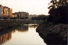
The Orontes is not easily navigable and the valley derives its historical importance as a road for north–south traffic; from Antioch south to Homs and thence to Damascus via al-Nabek.
In 64 BCE Pompey took the Orontes river valley and made it part of the new Roman province of Syria with Antioch as its capital.
[16] In addition to Lake Homs, further Roman dams and dykes would be built along the Orontes river around Apamea, to better irrigate the Ghab plain.
The French writer Maurice Barrès purportedly transcribed in Un jardin sur l'Oronte (1922) a story that an Irish archaeologist had translated for him from a manuscript one evening in June 1914 at a café in Hama by the Orontes.