Osmore River
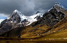
The river has its origin in the snow peaks of the Chuqi Ananta and Arundane mountains, at an elevation of 5,100 metres (16,700 ft) above sea level.
[1] An initial reconnaissance of the archaeological treasures of the valley carried out in the 1980s revealed more than 500 archeological sites dated from 10,000 years of human occupation.
[1] The river flows along a geological fault known as Cholo fault, and flows over a length of 480 kilometres (300 mi)draining an area of 1,343 square miles (3,480 km2) (of which 680 square kilometres (260 sq mi) are in a wet basin, located above 3,900 metres (12,800 ft)[1]).
The midsection contains farmland, the city of Moquegua, the historical Tiwanaku town of Omo, and the Yaral site.
[6] The presence of the Tiwanaku state's existence in the Moquegua Region was determined in 1981, with 17 sites located in the Osmore drainage area.
In the late 19th century, high tides of the Pacific Ocean flooded the town, and the residents relocated to Ilo, on higher ground.
However, at lower elevations rainfall is almost nil and hence considered as the "world's driest desert, where decades can pass without even a shower.
The river's run off source is seasonal precipitation including snow melt from the western cordillera of the Andes.
In the flat valley where the Asana archaeological site was located, the geological and geomorphological features are causative factors for its existence.
[8] The valley has fertile land where the dominant crops grown are grapes (from 1970s), corn (maize), pepper (aji), and cotton.
[12][13] Archaeological research not only covered the Asana in the higher reaches of the river in the Sierra but also in the Middle Horizon (500-1000AD) and the lower valley pre-Hispanic sites.
[14] The cave was studied in 1963 at the initiative of South Peru Copper Corporation (as they found large cache of artifacts during their mining operations) funded the study of the paintings in the caves by archeologists from Lima[2]) by Jorge C. Muelle which led to the discovery of the rupestral art.
It is a joint effort of the Field Museum of Lima, the Peruvian Museum of Health Sciences, and the Peruvian National Cultural Institute supported by the South Peru Copper Corporation with the objective of investigating, conserving, and promoting regional cultural heritage of Moquegua's portion of Contisuyu.
[19] Cerro Trapiche was another a Wari/Huaracane site in the middle valley near Tiwanaku settlements; it includes a walled hill peak with slingstone caches.
When emperor Mayta Capac of the Inca attacked the area he surrounded the hill as the local residents had moved to the safety of the Cerro Baul cliff, which could be approached by a tortuous route.
After 50 days of siege when the inhabitants of Moquegua did not get any food or water, they surrendered voluntarily after they ascertained that Mayta Capac would not harm them at all.
Now the ruins of the store houses and other remnant structures of the original inhabitants (not of Incas) are seen here in the backdrop of the snow-covered peaks of the Andes.
Now the "citadel city of Cerro Baul" (covering an area of 8 hectares (20 acres)) is witness to some ancient architecture with many ruins containing large cache of artifacts, designed textiles, and mummified human remains.
[2] On both sides of the river valley agricultural terraces abutting the hills and with canal systems are seen in an abandoned state.
[2] Torata is another ancient settlement in the Sierra mountains, where the local inhabitants moved from the Cerro Baul, after Incas had forced them to do so.
The war ended with the defeat of patriots whose army was completely routed two days later at the Battle of Moquegua with support of Gen José de Canterac.
In the past, the agricultural lands were used to grow maize, beans, cotton, and fruit trees of avocado which are now replaced by grapes which are brewed to make the popular Pisco brandy.