Otelfingen
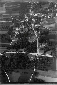
The centre of the village, with its typical timber-framed houses, is listed in the Federal Inventory of Swiss Sites of National Importance (ISOS)[3] Otelfingen is first mentioned in 1044 as Otilingun though there is some debate about this identification.
Of the rest of the land, 14.8% is settled (buildings or roads) and the remainder (1%) is non-productive (rivers, glaciers or mountains).
[5] The majority of the municipality is the village of Otelfingen, a Haufendorf (an irregular, unplanned and quite closely packed village, built around a central square) located in the Furttal on the border with the Canton of Aargau.
The wettest month is June during which time Otelfingen receives an average of 116 mm (4.6 in) of precipitation.
The driest month of the year is October, during which time the municipality receives an average of 72 mm (2.8 in).